Approximate Location Map
Large Map »
Latitude: 52.25 / 52°14'59"N
Longitude: 1.2003 / 1°12'1"E
OS Eastings: 618552
OS Northings: 266139
OS Grid: TM185661
Mapcode National: GBR VLR.Y0R
Mapcode Global: VHL9V.RQF0
Plus Code: 9F4366X2+X4
Entry Name: 1 Moat Farm
Listing Date: 24 June 1988
Grade: II
Source: Historic England
Source ID: 1300982
English Heritage Legacy ID: 281555
ID on this website: 101300982
Location: Kenton, Mid Suffolk, IP14
County: Suffolk
District: Mid Suffolk
Civil Parish: Kenton
Traditional County: Suffolk
Lieutenancy Area (Ceremonial County): Suffolk
Church of England Parish: Kenton All Saints
Church of England Diocese: St.Edmundsbury and Ipswich
Tagged with: Farmhouse
This list entry was subject to a Minor Amendment on 22 August 2023 to amend the name and address and to reformat the text to current standards
TM 16 NE
1/131
KENTON
CHURCH LANE
Moat Farm
No 1
(Formerly listed as Moat Farmhouse)
II
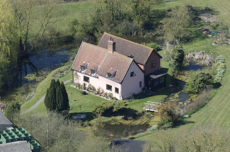
Farmhouse. Mid C14 and later C17, in two phases, forming a two-cell house; large rear addition of 1985, in parallel with old range. Timber framed and plastered, the left gable end with C19 red brick casing to eaves level. Pantiled roof, less steeply-pitched over the later right cell. One and a half storeys. Casement windows without glazing bars, all of c.1985. Left cell has two raking dormers, the right cell one flat-roofed dormer. Central internal stack with plain axial shaft, the lower portion original, the upper part C19. Entrance door to rear.
Interior. Earliest section comprises one and a half bays of a two-bay former open hall. The open truss has an arched-braced tie beam, the centre portion removed. This supports plain square or oblong queen-posts, splayed at the base, with solid braces to the arcade plates. The collar has been lost, probably together with the remainder of the original roof structure. Stop-splayed scarf joints in arcade plates and front wallplate. A little C14 framing in the gable end, otherwise concealed. Inserted floor has long axial beam, the joists concealed. C17 structure in two bays, with plain first floor studding. Butt purlin roof. Back-to-back open fireplaces on ground floor. Encircling medieval moat.
Listing NGR: TM1855266139
External links are from the relevant listing authority and, where applicable, Wikidata. Wikidata IDs may be related buildings as well as this specific building. If you want to add or update a link, you will need to do so by editing the Wikidata entry.


Other nearby listed buildings
