Approximate Location Map
Large Map »
Latitude: 52.2968 / 52°17'48"N
Longitude: 0.8306 / 0°49'50"E
OS Eastings: 593115
OS Northings: 270293
OS Grid: TL931702
Mapcode National: GBR RFQ.SZT
Mapcode Global: VHKD0.BJYM
Plus Code: 9F427RWJ+P6
Entry Name: Smithy to South of Holmlea
Listing Date: 11 July 1983
Grade: II
Source: Historic England
Source ID: 1180907
English Heritage Legacy ID: 283614
ID on this website: 101180907
Location: Ixworth, West Suffolk, IP31
County: Suffolk
District: West Suffolk
Civil Parish: Ixworth
Built-Up Area: Ixworth
Traditional County: Suffolk
Lieutenancy Area (Ceremonial County): Suffolk
Church of England Parish: Ixworth St Mary
Church of England Diocese: St.Edmundsbury and Ipswich
Tagged with: Smithy
TL 9270-9370
5/37
IXWORTH
HIGH STREET
(WEST SIDE)
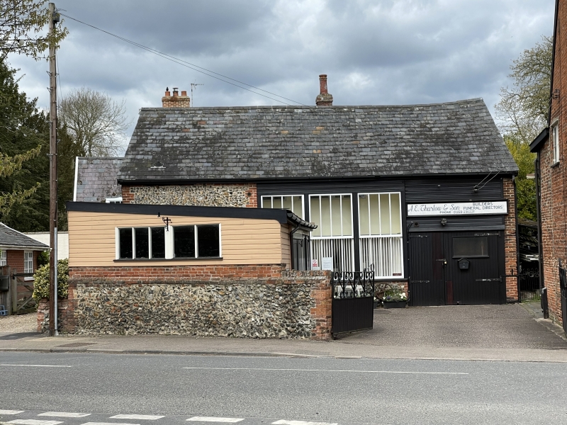
Smithy to South of Holmlea
GV
II
A smithy, still in use. Late C18. Random flint, with red brick dressings and
slate roof. Range of 3 long 4-light windows with central transom.
Listing NGR: TL9311570293
External links are from the relevant listing authority and, where applicable, Wikidata. Wikidata IDs may be related buildings as well as this specific building. If you want to add or update a link, you will need to do so by editing the Wikidata entry.


Other nearby listed buildings
