Approximate Location Map
Large Map »
Latitude: 52.2856 / 52°17'8"N
Longitude: 0.6763 / 0°40'34"E
OS Eastings: 582644
OS Northings: 268649
OS Grid: TL826686
Mapcode National: GBR QDC.PSP
Mapcode Global: VHJGG.NTX6
Plus Code: 9F427MPG+6G
Entry Name: 8-10, Bury Road
Listing Date: 21 February 1972
Grade: II
Source: Historic England
Source ID: 1180644
English Heritage Legacy ID: 283768
ID on this website: 101180644
Location: Hengrave, West Suffolk, IP28
County: Suffolk
District: West Suffolk
Civil Parish: Hengrave
Traditional County: Suffolk
Lieutenancy Area (Ceremonial County): Suffolk
Church of England Parish: Flempton St Catherine of Alexandria
Church of England Diocese: St.Edmundsbury and Ipswich
Tagged with: Building Thatched cottage
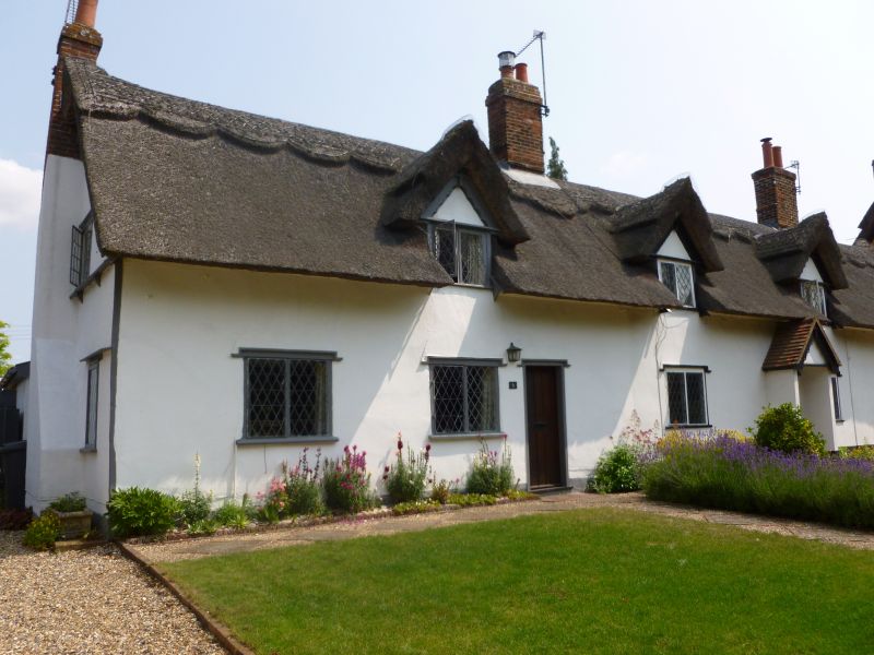
TL 86 NW HENGRAVE BURY ROAD
4/61 Nos 8 to 10 (consec)
21.2.72
- II
A row of cottages, C18, 1 storey with attics, 1 or 2 windows each. Timber-
framed, rendered. Thatched roof, with gabled casement dormers and axial
chimneys. 2-light hould-moulded windows with leaded casements. Boarded
entrance doors.
Listing NGR: TL8264468648
External links are from the relevant listing authority and, where applicable, Wikidata. Wikidata IDs may be related buildings as well as this specific building. If you want to add or update a link, you will need to do so by editing the Wikidata entry.


Other nearby listed buildings
