Approximate Location Map
Large Map »
Latitude: 52.3369 / 52°20'12"N
Longitude: 0.8049 / 0°48'17"E
OS Eastings: 591194
OS Northings: 274680
OS Grid: TL911746
Mapcode National: GBR RF9.DBB
Mapcode Global: VHKCS.WJXD
Plus Code: 9F428RP3+PX
Entry Name: Two Barns to North East of Manor Farmhouse
Listing Date: 14 December 1983
Grade: II
Source: Historic England
Source ID: 1031293
English Heritage Legacy ID: 284059
ID on this website: 101031293
Location: Honington, West Suffolk, IP31
County: Suffolk
District: West Suffolk
Civil Parish: Honington
Built-Up Area: Honington
Traditional County: Suffolk
Lieutenancy Area (Ceremonial County): Suffolk
Church of England Parish: Honington All Saints
Church of England Diocese: St.Edmundsbury and Ipswich
Tagged with: Building
TL 97 SW HONINGTON SAPISTON ROAD (NORTH SIDE)
3/82 Two barns to north-east of
- Manor Famhouse
GV II
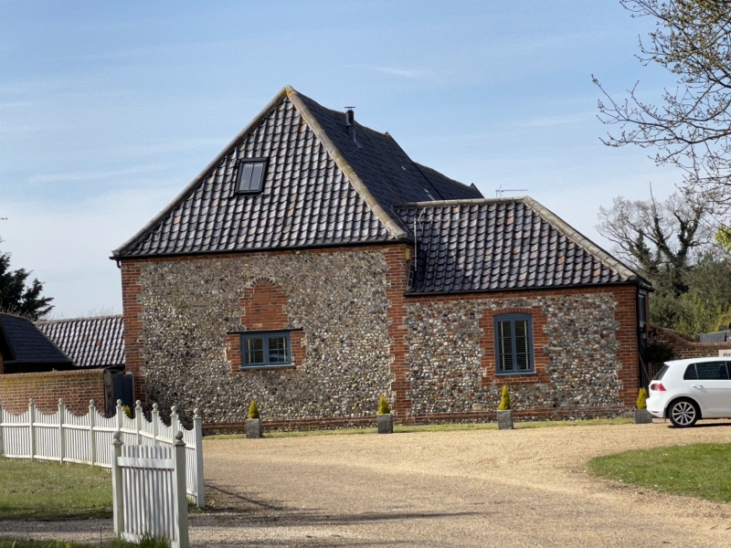
A pair of barns set end to end on the east side of a group of outbuildings. C18
and early C19. Part timber-framed, but mainly random flint with red brick.
Black glazed pantiled roofs. The rear building is the earlier, with an original
upper storey, probably used as a hayloft. 4 bays. Timber-framed, with the
remains of old plaster and some weatherboarding along the west side: louvred
upper windows: butt purlin roof. A lean-to early C19 extension along the east
side in red brick with black glazed pantiles. A larger barn adjoins on the
south with a random flint face over random red brick: red brick rusticated
quoins and dentil cornice. Hipped roof on south. A lean-to extension in the
same materials along the east side, and a large single-storey hipped porch. A
blocked window in the south wall with arched head and rusticated surround. In
the west wall a long ventilation opening on each side of the high central
doorway, with arched head and rusticated surrounds, divided by 2 brick
mullions: similar blocked openings along the east wall.
Listing NGR: TL9119474680
External links are from the relevant listing authority and, where applicable, Wikidata. Wikidata IDs may be related buildings as well as this specific building. If you want to add or update a link, you will need to do so by editing the Wikidata entry.


Other nearby listed buildings
