Approximate Location Map
Large Map »
Latitude: 52.3544 / 52°21'15"N
Longitude: 0.8888 / 0°53'19"E
OS Eastings: 596830
OS Northings: 276853
OS Grid: TL968768
Mapcode National: GBR SGJ.9KF
Mapcode Global: VHKCV.C27Y
Plus Code: 9F429V3Q+QG
Entry Name: Church Farmhouse
Listing Date: 14 July 1955
Grade: II
Source: Historic England
Source ID: 1376994
English Heritage Legacy ID: 284362
ID on this website: 101376994
Location: Barningham, West Suffolk, IP31
County: Suffolk
District: West Suffolk
Civil Parish: Barningham
Built-Up Area: Barningham
Traditional County: Suffolk
Lieutenancy Area (Ceremonial County): Suffolk
Church of England Parish: Barningham St Andrew
Church of England Diocese: St.Edmundsbury and Ipswich
Tagged with: Farmhouse Thatched farmhouse
This list entry was subject to a Minor Amendment on 16/04/2020
TL 97 NE
1/9
BARNINGHAM
CHURCH ROAD
Church Farmhouse
14.7.55
GV
II
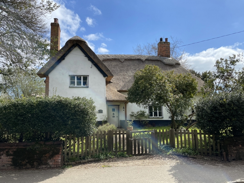
Farmhouse. Late C15, extended late C18/early C19. Part two storeys, part one-and-a half; basic two-cell plan; now T-shaped form. Timber framed and rendered, with old roughcast and thatched roof.
The main range has a half-hipped roof to the south, and was originally half-hipped at both ends; the cross-wing is gabled. An internal chimney-stack with a plain shaft is set near the south end of the front. Three-light casement windows with a single bar to both ranges; one gabled dormer with plain tiled roof. One old three-light upper casement window, with square-leaded panes and crown glass, at the south end. Entry in the angle between the two ranges, with a small thatched porch over, leading into a passageway forming part of one bay of the two-bay hall. This was originally open to the roof, and has a plain inserted beam-and-joist ceiling. Plain clasped purlin roof, smoke-blackened over the former hall area. Service-end partition visible from first floor with the inserted chimney-stack against it.
Listing NGR: TL9683076853
External links are from the relevant listing authority and, where applicable, Wikidata. Wikidata IDs may be related buildings as well as this specific building. If you want to add or update a link, you will need to do so by editing the Wikidata entry.


Other nearby listed buildings
