Approximate Location Map
Large Map »
Latitude: 52.1553 / 52°9'19"N
Longitude: 1.5248 / 1°31'29"E
OS Eastings: 641204
OS Northings: 256638
OS Grid: TM412566
Mapcode National: GBR XR0.VQB
Mapcode Global: VHM82.C3Y2
Plus Code: 9F435G4F+4W
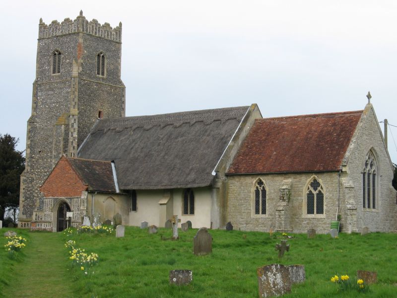
Entry Name: Church of St Botolph
Listing Date: 16 March 1966
Last Amended: 2 May 1984
Grade: II
Source: Historic England
Source ID: 1198033
English Heritage Legacy ID: 285156
ID on this website: 101198033
Location: St Botolph's Church, Iken, East Suffolk, IP12
County: Suffolk
District: East Suffolk
Civil Parish: Iken
Traditional County: Suffolk
Lieutenancy Area (Ceremonial County): Suffolk
Church of England Parish: Iken St Botolph
Church of England Diocese: St.Edmundsbury and Ipswich
Tagged with: Church building
TM 45 NW IKEN CHURCH LANE
2/14 Church of St. Botolph
16.3.66 (Formerly listed under General)
- II
Parish church. C15. The now burnt out nave was of c.1300. Chancel c.1862 still
used for services. West tower in Knapped flint with ashlar base and knapped
flint diagonal buttresses. C15 octagonal font now resited in tower.
Listing NGR: TM4120456638
External links are from the relevant listing authority and, where applicable, Wikidata. Wikidata IDs may be related buildings as well as this specific building. If you want to add or update a link, you will need to do so by editing the Wikidata entry.


Other nearby listed buildings
