Approximate Location Map
Large Map »
Latitude: 52.2211 / 52°13'16"N
Longitude: 1.3429 / 1°20'34"E
OS Eastings: 628430
OS Northings: 263371
OS Grid: TM284633
Mapcode National: GBR WNN.QBN
Mapcode Global: VHLB4.7F9M
Plus Code: 9F4368CV+F5
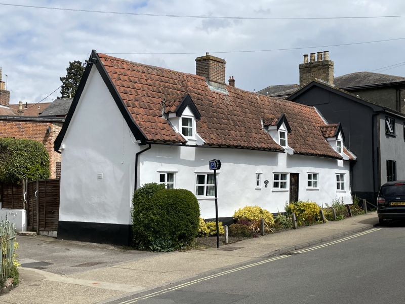
Entry Name: The Maltings
Listing Date: 18 December 1985
Grade: II
Source: Historic England
Source ID: 1030370
English Heritage Legacy ID: 286368
ID on this website: 101030370
Location: Framlingham, East Suffolk, IP13
County: Suffolk
District: East Suffolk
Civil Parish: Framlingham
Built-Up Area: Framlingham
Traditional County: Suffolk
Lieutenancy Area (Ceremonial County): Suffolk
Church of England Parish: Framlingham St Michael
Church of England Diocese: St.Edmundsbury and Ipswich
Tagged with: Building
TM 26 SE FRAMLINGHAM FORE STREET
4/90 The Maltings
-
GV II
House, formerly divided into 3 cottages. C18. 1 storey and attic. Timber-
framed and rendered; clay pantiles; an internal chimney-stack with a plain red
brick shaft. 4 small sliding sash windows; 3 gabled dormers; old plank door.
Restored interior.
Listing NGR: TM2843063371
External links are from the relevant listing authority and, where applicable, Wikidata. Wikidata IDs may be related buildings as well as this specific building. If you want to add or update a link, you will need to do so by editing the Wikidata entry.


Other nearby listed buildings
