Approximate Location Map
Large Map »
Latitude: 51.1756 / 51°10'32"N
Longitude: -0.0262 / 0°1'34"W
OS Eastings: 538070
OS Northings: 143666
OS Grid: TQ380436
Mapcode National: GBR KLC.66S
Mapcode Global: VHGSL.HQH5
Plus Code: 9C3X5XGF+6G
Entry Name: The Garth
Listing Date: 11 June 1958
Grade: II*
Source: Historic England
Source ID: 1205754
English Heritage Legacy ID: 287472
ID on this website: 101205754
Location: Lingfield, Tandridge, Surrey, RH7
County: Surrey
District: Tandridge
Civil Parish: Lingfield
Built-Up Area: Lingfield
Traditional County: Surrey
Lieutenancy Area (Ceremonial County): Surrey
Church of England Parish: Lingfield St Peter and St Paul
Church of England Diocese: Southwark
Tagged with: Architectural structure
TQ 34SE LINGFIELD C.P. NEWCHAPEL ROAD
9/229 The Garth
11/6/58 II*
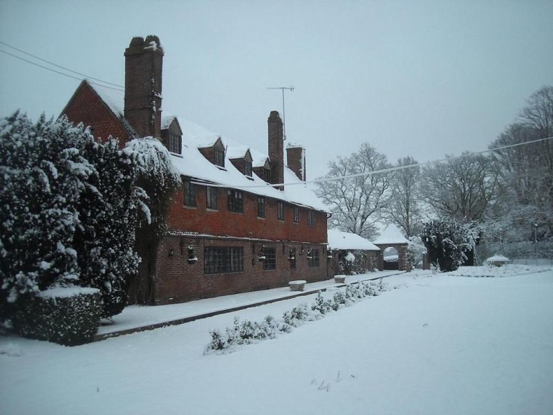
Former Parish Workhouse with house attached, new house. 1729 altered by W.H.
Godfrey in 1919. Red and blue brick below, plain tiled to first floor left,
diamond patterning on right and across former entrance front. Plain tiled roof
with 3 rear stacks to left of centre and right, one to right with beehive top.
Entrance front row to rear. 2 storeys with 3 storey gabled bay to left, single
storey wing projecting from front left. Attic under 2 leaded casement dormers,
six casement windows across first floor, the majority leaded. Four windows to
ground floor left. Planked door to left of centre under flat hood on volute
foliage brackets.
Garden front:- (former entrance front) brick plinth, 4 leaded gabled casement
dormers to left, 8 leaded casements across first floor, 4 on ground floor.
Left hand return front:- angle bay to ground floor.
Interior:- Beamed ceilings. with chamfered main beams.
PEVSNER: Buildings of England, Surrey (1971) p. 350.
Listing NGR: TQ3807043666
External links are from the relevant listing authority and, where applicable, Wikidata. Wikidata IDs may be related buildings as well as this specific building. If you want to add or update a link, you will need to do so by editing the Wikidata entry.


Other nearby listed buildings
