Approximate Location Map
Large Map »
Latitude: 51.2548 / 51°15'17"N
Longitude: 0.0152 / 0°0'54"E
OS Eastings: 540721
OS Northings: 152551
OS Grid: TQ407525
Mapcode National: GBR KKF.BN5
Mapcode Global: VHHPP.6QWG
Plus Code: 9F327238+W3
Entry Name: Limpsfield Pound
Listing Date: 19 November 1984
Last Amended: 8 November 1999
Grade: II
Source: Historic England
Source ID: 1189471
English Heritage Legacy ID: 287860
ID on this website: 101189471
Location: Limpsfield, Tandridge, Surrey, RH8
County: Surrey
District: Tandridge
Civil Parish: Limpsfield
Built-Up Area: Oxted
Traditional County: Surrey
Lieutenancy Area (Ceremonial County): Surrey
Church of England Parish: Limpsfield and Titsey
Church of England Diocese: Southwark
Tagged with: Architectural structure
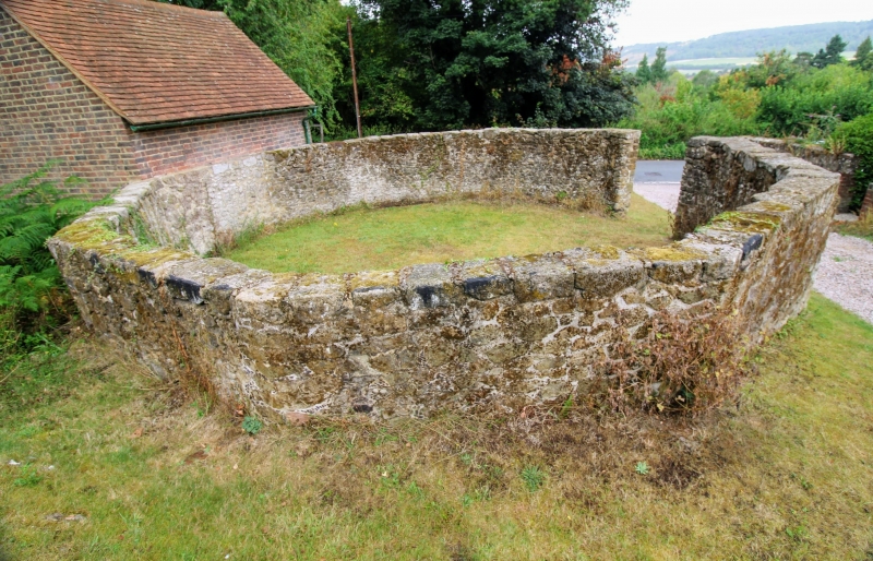
TQ 45 SW LIMPSFIELD WOLFS ROW
303/7/205 Limpsfield Pound
19.11.1984 II
Cattle Pound. Mid C18. Galleted coursed stone walls c51/2 foot high. Polygonal
c12 foot in diameter. A pound for stray animals and in use until C19. Bronze
Plaque on west side presented by Limpsfield Parish Council.
Listing NGR: TQ4072152551
External links are from the relevant listing authority and, where applicable, Wikidata. Wikidata IDs may be related buildings as well as this specific building. If you want to add or update a link, you will need to do so by editing the Wikidata entry.


Other nearby listed buildings
