Approximate Location Map
Large Map »
Latitude: 51.2525 / 51°15'8"N
Longitude: -0.0157 / 0°0'56"W
OS Eastings: 538574
OS Northings: 152240
OS Grid: TQ385522
Mapcode National: GBR KKD.GVG
Mapcode Global: VHGS6.PS16
Plus Code: 9C3X7X2M+XP
Entry Name: The Nest
Listing Date: 19 November 1984
Grade: II
Source: Historic England
Source ID: 1029703
English Heritage Legacy ID: 287895
ID on this website: 101029703
Location: Tandridge, Surrey, RH8
County: Surrey
District: Tandridge
Civil Parish: Oxted
Built-Up Area: Oxted
Traditional County: Surrey
Lieutenancy Area (Ceremonial County): Surrey
Church of England Parish: Oxted
Church of England Diocese: Southwark
Tagged with: Building
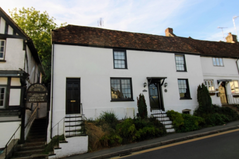
TQ 35SE OXTED C.P. HIGH STREET
(south side)
6/240 No. 59 (The Nest)
GV II
House. C17. Timber framed on rubble and brick plinth, rendered cladding with plain
tiled roof, half hipped to left; rear stack to left. 2 storeys over basement,
2 glazing bar sash windows on first floor. 6 panel door to right of centre under
flat porch hood on braces up a flight of 7 steps. Further 6 panel door to left up
flight of 8 steps.
Listing NGR: TQ3857452240
External links are from the relevant listing authority and, where applicable, Wikidata. Wikidata IDs may be related buildings as well as this specific building. If you want to add or update a link, you will need to do so by editing the Wikidata entry.


Other nearby listed buildings
