Approximate Location Map
Large Map »
Latitude: 51.3322 / 51°19'55"N
Longitude: -0.2612 / 0°15'40"W
OS Eastings: 521230
OS Northings: 160669
OS Grid: TQ212606
Mapcode National: GBR 93.YLL
Mapcode Global: VHGRP.FS73
Plus Code: 9C3X8PJQ+VG
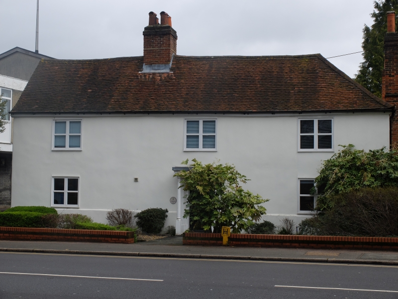
Entry Name: The Hermitage
Listing Date: 22 March 1974
Grade: II
Source: Historic England
Source ID: 1212446
English Heritage Legacy ID: 290657
ID on this website: 101212446
Location: Epsom, Epsom and Ewell, Surrey, KT17
County: Surrey
District: Epsom and Ewell
Electoral Ward/Division: Town
Parish: Non Civil Parish
Built-Up Area: Epsom
Traditional County: Surrey
Lieutenancy Area (Ceremonial County): Surrey
Church of England Parish: Epsom St Martin
Church of England Diocese: Guildford
Tagged with: Architectural structure
1. EPSOM
1086
CHURCH STREET
(East Side)
The Hermitage
TQ 2160 30/29B
II
2.
C17 - C18. Two storeys, roughcast, three wide spaced casements. Central
C19 and modern tiled porch on posts. Old tile roof hipped to right.
Central Square stack. Tall brick stacks at side.
Listing NGR: TQ2123060669
External links are from the relevant listing authority and, where applicable, Wikidata. Wikidata IDs may be related buildings as well as this specific building. If you want to add or update a link, you will need to do so by editing the Wikidata entry.


Other nearby listed buildings
