Approximate Location Map
Large Map »
Latitude: 51.2132 / 51°12'47"N
Longitude: -0.8013 / 0°48'4"W
OS Eastings: 483821
OS Northings: 146677
OS Grid: SU838466
Mapcode National: GBR DB3.VLM
Mapcode Global: VHDY2.2R7V
Plus Code: 9C3X657X+7F
Entry Name: Gas Lamp to West of Church Tower
Listing Date: 29 December 1972
Grade: II
Source: Historic England
Source ID: 1378274
English Heritage Legacy ID: 290915
ID on this website: 101378274
Location: St Andrew's Church, Farnham, Waverley, Surrey, GU9
County: Surrey
District: Waverley
Civil Parish: Farnham
Built-Up Area: Farnham
Traditional County: Surrey
Lieutenancy Area (Ceremonial County): Surrey
Church of England Parish: Farnham
Church of England Diocese: Guildford
Tagged with: Gas streetlight
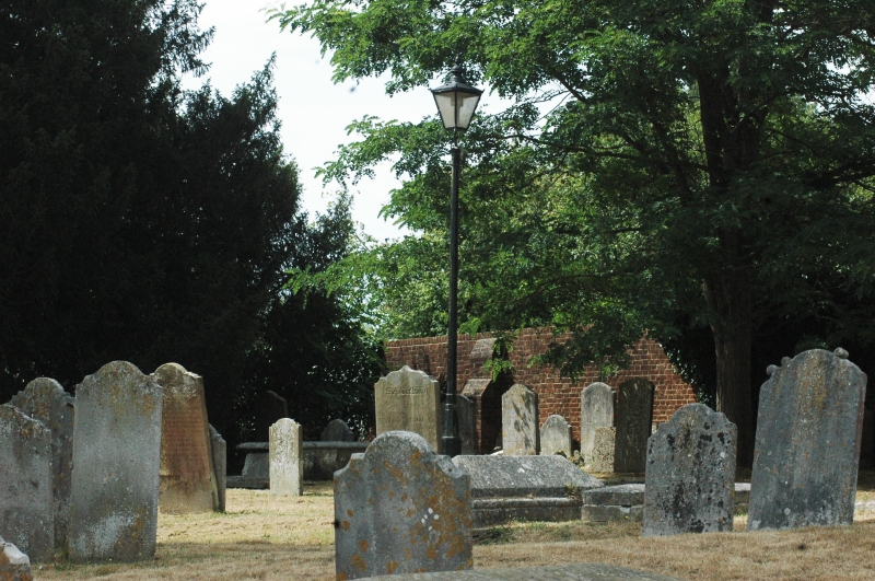
1099 CHURCHYARD
Gas lamp to West of Church Tower
SU 8346 NE 5/208
GV II
Later C19. Tapering octagonal shaft with bands of necking; moulded octagonal
plinth. Quadrangular l8Jl1p with cresting. Still run by gas [1971]. No number apparent.
Listing NGR: SU8382446677
External links are from the relevant listing authority and, where applicable, Wikidata. Wikidata IDs may be related buildings as well as this specific building. If you want to add or update a link, you will need to do so by editing the Wikidata entry.


Other nearby listed buildings
