Approximate Location Map
Large Map »
Latitude: 50.9059 / 50°54'21"N
Longitude: 0.4028 / 0°24'10"E
OS Eastings: 569035
OS Northings: 114579
OS Grid: TQ690145
Mapcode National: GBR NV6.0PJ
Mapcode Global: FRA C6QQ.4RJ
Plus Code: 9F22WC43+94
Entry Name: Ashburnham Place (Christian Conference and Prayer Centre)
Listing Date: 13 May 1987
Grade: II
Source: Historic England
Source ID: 1229643
English Heritage Legacy ID: 292070
ID on this website: 101229643
Location: The Pound, Rother, East Sussex, TN33
County: East Sussex
District: Rother
Civil Parish: Ashburnham
Traditional County: Sussex
Lieutenancy Area (Ceremonial County): East Sussex
Church of England Parish: Ashburnham St Peter
Church of England Diocese: Chichester
Tagged with: Building
TQ 61 SE ASHBURNHAM KITCHENHAN ROAD
28/2 Ashburnham Place.
(Christian Conference and
Prayer Centre).
II
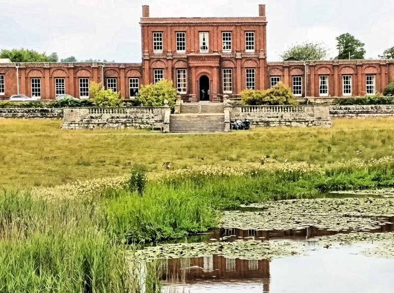
The facade dates from 1845 circa. Red brick and diaper pattern of grey headers.
Cornice above each floor and parapet. Glazing bars intact. The central portion
is now of two storeys and. five windows. Each window bay is flanked by pilasters.
Ground floor windows are set in round-headed arcading. Large central square
porch with round-headed archway. The wings are of one storey. The first two
window-bays on each side of the centre are recessed with three window-bays each
projecting beyond. Modern conference wings to north. The Ashburnham family
occupied a house on this site from before the Conquest until the death of Lady
Catherine Ashburnham in 1953. It was a large mansion of several periods, of
which the main portion was C18, refaced in 1845 circa. Most of this was demolished
about- 1955. What remains is the south front, which retains its original form
of a central block and flanking wings of lower elevation but both centre and
wings have been reduced in height.
Listing NGR: TQ6903514579
External links are from the relevant listing authority and, where applicable, Wikidata. Wikidata IDs may be related buildings as well as this specific building. If you want to add or update a link, you will need to do so by editing the Wikidata entry.


Other nearby listed buildings
