Approximate Location Map
Large Map »
Latitude: 50.9172 / 50°55'2"N
Longitude: 0.4841 / 0°29'2"E
OS Eastings: 574706
OS Northings: 116024
OS Grid: TQ747160
Mapcode National: GBR PWF.H5N
Mapcode Global: FRA C6XP.6F6
Plus Code: 9F22WF8M+VJ
Entry Name: 49, 50 and 51, High Street
Listing Date: 13 May 1987
Grade: II
Source: Historic England
Source ID: 1044184
English Heritage Legacy ID: 292158
ID on this website: 101044184
Location: Battle, Rother, East Sussex, TN33
County: East Sussex
District: Rother
Civil Parish: Battle
Built-Up Area: Battle
Traditional County: Sussex
Lieutenancy Area (Ceremonial County): East Sussex
Church of England Parish: Battle St Mary the Virgin
Church of England Diocese: Chichester
Tagged with: Building
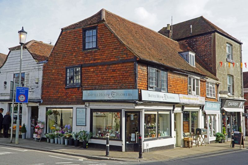
TQ 7416-7516 BATTLE HIGH STREET
(north east side)
40/10 Nos 49, 50 and 51
GV II
One building. Probably C17. Two storeys and attic. Three windows. One dormer.
Ground floor red brick, above tile-hung. Tiled roof. Casement windows. Modern
shop fronts.
Listing NGR: TQ7470416029
External links are from the relevant listing authority and, where applicable, Wikidata. Wikidata IDs may be related buildings as well as this specific building. If you want to add or update a link, you will need to do so by editing the Wikidata entry.


Other nearby listed buildings
