Approximate Location Map
Large Map »
Latitude: 50.9177 / 50°55'3"N
Longitude: 0.4842 / 0°29'2"E
OS Eastings: 574710
OS Northings: 116080
OS Grid: TQ747160
Mapcode National: GBR PWF.97N
Mapcode Global: FRA C6XP.0G2
Plus Code: 9F22WF9M+3M
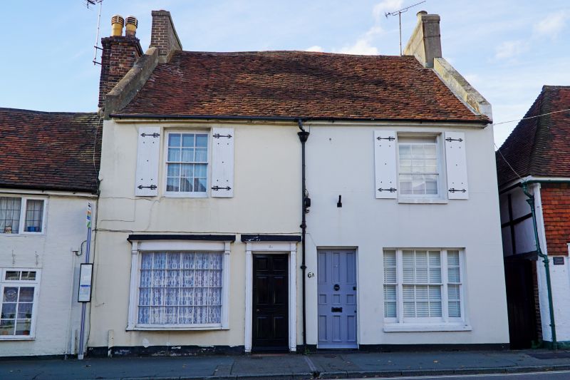
Entry Name: 6A and 6B, Mount Street
Listing Date: 13 May 1987
Grade: II
Source: Historic England
Source ID: 1278224
English Heritage Legacy ID: 292198
ID on this website: 101278224
Location: Battle, Rother, East Sussex, TN33
County: East Sussex
District: Rother
Civil Parish: Battle
Built-Up Area: Battle
Traditional County: Sussex
Lieutenancy Area (Ceremonial County): East Sussex
Church of England Parish: Battle St Mary the Virgin
Church of England Diocese: Chichester
Tagged with: Building
TQ 7416-7516 BATTLE MOUNT STREET
(west side)
40/14 Nos 6B and 6A
GV II
One building. Pair of early C19 houses. Two storeys. Two windows. Stuccoed.
Tiled roof. Glazing bars intact. No 6B has a curved window on ground floor and
a doorway with pilasters and door of six fielded panels.
Listing NGR: TQ7471116082
External links are from the relevant listing authority and, where applicable, Wikidata. Wikidata IDs may be related buildings as well as this specific building. If you want to add or update a link, you will need to do so by editing the Wikidata entry.


Other nearby listed buildings
