Approximate Location Map
Large Map »
Latitude: 50.8071 / 50°48'25"N
Longitude: 0.1569 / 0°9'24"E
OS Eastings: 552068
OS Northings: 103053
OS Grid: TQ520030
Mapcode National: GBR LSC.BGZ
Mapcode Global: FRA C66Y.YRL
Plus Code: 9F22R544+RQ
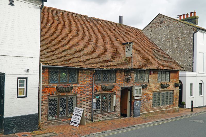
Entry Name: Moonrakers
Listing Date: 12 August 1981
Grade: II
Source: Historic England
Source ID: 1043341
English Heritage Legacy ID: 294905
ID on this website: 101043341
Location: Alfriston, Wealden, East Sussex, BN26
County: East Sussex
District: Wealden
Civil Parish: Alfriston
Built-Up Area: Alfriston
Traditional County: Sussex
Lieutenancy Area (Ceremonial County): East Sussex
Church of England Parish: Alfriston with Lullington
Church of England Diocese: Chichester
Tagged with: Building
ALFRISTON HIGH STREET
1.
5208
(east side)
Moonrakers
TQ 5203 39/61
II GV
2.
C17 or earlier timber-framed building, refaced with red brick and grey headers
alternately. Hipped tiled roof. Modern csement windows. Two storeys.
Four windows.
Listing NGR: TQ5206703054
External links are from the relevant listing authority and, where applicable, Wikidata. Wikidata IDs may be related buildings as well as this specific building. If you want to add or update a link, you will need to do so by editing the Wikidata entry.


Other nearby listed buildings
