Approximate Location Map
Large Map »
Latitude: 51.045 / 51°2'42"N
Longitude: 0.2192 / 0°13'9"E
OS Eastings: 555662
OS Northings: 129642
OS Grid: TQ556296
Mapcode National: GBR MQW.G7S
Mapcode Global: FRA C6BC.57K
Plus Code: 9F3226W9+2M
Entry Name: Chapel House
Listing Date: 31 December 1982
Grade: II
Source: Historic England
Source ID: 1353615
English Heritage Legacy ID: 296659
ID on this website: 101353615
Location: Rotherfield, Wealden, East Sussex, TN6
County: East Sussex
District: Wealden
Civil Parish: Rotherfield
Built-Up Area: Rotherfield
Traditional County: Sussex
Lieutenancy Area (Ceremonial County): East Sussex
Church of England Parish: Rotherfield St Denys
Church of England Diocese: Chichester
Tagged with: House
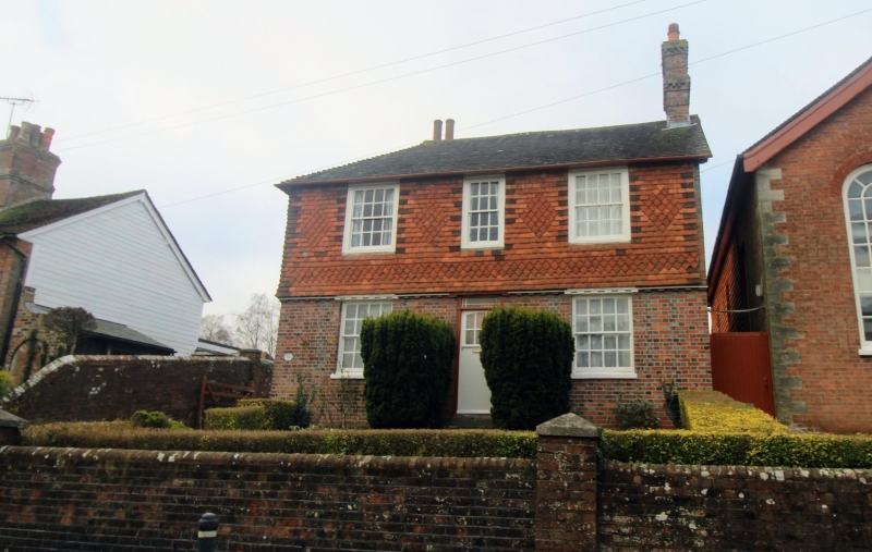
ROTHERFIELD SOUTH STREET
1.
5208
(west side)
Chapel House
TQ 5529 38/230
II
2.
Early C19. Two storeys. Three windows. Ground floor red brick and grey headers,
above tile-hung with modillion cornice between. Eaves cornice. Tiled roof.
Glazing bars intact.
Listing NGR: TQ5566229642
External links are from the relevant listing authority and, where applicable, Wikidata. Wikidata IDs may be related buildings as well as this specific building. If you want to add or update a link, you will need to do so by editing the Wikidata entry.


Other nearby listed buildings
