Approximate Location Map
Large Map »
Latitude: 50.9737 / 50°58'25"N
Longitude: 0.0952 / 0°5'42"E
OS Eastings: 547196
OS Northings: 121451
OS Grid: TQ471214
Mapcode National: GBR LQ5.T1W
Mapcode Global: FRA C62J.QXH
Plus Code: 9F22X3FW+F3
Entry Name: Copping Hall
Listing Date: 26 November 1953
Grade: II*
Source: Historic England
Source ID: 1353642
English Heritage Legacy ID: 296688
ID on this website: 101353642
Location: Uckfield, Wealden, East Sussex, TN22
County: East Sussex
District: Wealden
Civil Parish: Uckfield
Built-Up Area: Uckfield
Traditional County: Sussex
Lieutenancy Area (Ceremonial County): East Sussex
Church of England Parish: Uckfield Holy Cross
Church of England Diocese: Chichester
Tagged with: House
UCKFIELD CHURCH STREET
1.
5208
(north side)
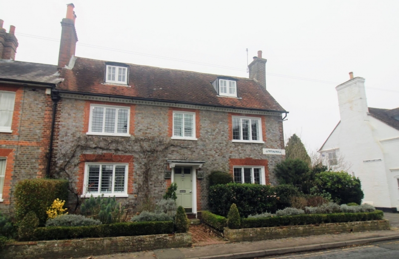
No 46 (Copping Hall)
TQ 4721 42/800 26.11.53
II* GV
2.
Early C18. Two storeys and attic. Three windows. Two dormers. Grey headers
with red brick dressings and quoins. Dentilled cornice. Tiled roof. Casement
windows with small square panes. Doorway with flat hood on brackets and door
of six fielded panels.
Listing NGR: TQ4719621451
External links are from the relevant listing authority and, where applicable, Wikidata. Wikidata IDs may be related buildings as well as this specific building. If you want to add or update a link, you will need to do so by editing the Wikidata entry.


Other nearby listed buildings
