Approximate Location Map
Large Map »
Latitude: 51.1347 / 51°8'4"N
Longitude: 0.1406 / 0°8'26"E
OS Eastings: 549864
OS Northings: 139450
OS Grid: TQ498394
Mapcode National: GBR LN9.SG8
Mapcode Global: VHHQB.DQ6Z
Plus Code: 9F3244MR+V7
Entry Name: Pound Farmhouse
Listing Date: 31 December 1982
Grade: II
Source: Historic England
Source ID: 1028037
English Heritage Legacy ID: 296913
ID on this website: 101028037
Location: Teasley Mead, Wealden, East Sussex, TN3
County: East Sussex
District: Wealden
Civil Parish: Withyham
Traditional County: Sussex
Lieutenancy Area (Ceremonial County): East Sussex
Church of England Parish: Withyham St Michael and All Angels
Church of England Diocese: Chichester
Tagged with: Farmhouse
WITHYHAM BLACKHAM
1.
5208
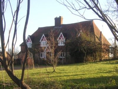
Pound Farmhouse
TQ 43 NE 5/150
II
2.
C17 or earlier house, altered in C19. Two storeys. Four windows. Ground
floor red brick and grey headers, above tile-hung. Tiled roof. Casement windows.
C19 gabled porch and matching gabled dormers with cusped barge-boards.
Listing NGR: TQ4986439450
External links are from the relevant listing authority and, where applicable, Wikidata. Wikidata IDs may be related buildings as well as this specific building. If you want to add or update a link, you will need to do so by editing the Wikidata entry.


Other nearby listed buildings
