Approximate Location Map
Large Map »
Latitude: 50.8556 / 50°51'20"N
Longitude: -0.5555 / 0°33'19"W
OS Eastings: 501769
OS Northings: 107227
OS Grid: TQ017072
Mapcode National: GBR FJ6.BCF
Mapcode Global: FRA 96QV.3D8
Plus Code: 9C2XVC4V+6Q
Entry Name: Town Gate and Castle Walls
Listing Date: 7 October 1974
Grade: II
Source: Historic England
Source ID: 1248038
English Heritage Legacy ID: 297200
ID on this website: 101248038
Location: Arundel, Arun, West Sussex, BN18
County: West Sussex
District: Arun
Civil Parish: Arundel
Built-Up Area: Arundel
Traditional County: Sussex
Lieutenancy Area (Ceremonial County): West Sussex
Church of England Parish: Arundel St Nicholas with Tortington
Church of England Diocese: Chichester
Tagged with: Architectural structure
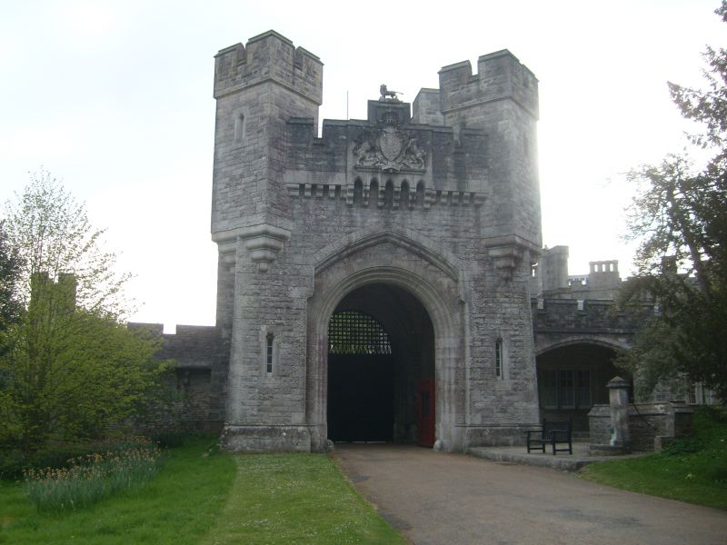
1.
5401 HIGH STREET
(East Side)
Town gate and Castle Walls
TQ 0107 1/92
II GV
2.
1850 (Date panel). Upper greensand. Ashlar plinth, coping and dressings: otherwise
rock-faced rustication.
Lodge adjoining gate is rectangular with 4 smaller rectangular turrets at angles.
Pointed archway with machicolation above. Wall has crenellated parapet, with
bartizans on outer side and semi-circular bastions on inner side. The Town Gate
and Castle Walls were built as a result of the proposal of 1833 whereby the Duke
of Norfolk undertook to build a new Town Hall at his own expense, in return for
the gift of the north part of the High Street, which he wished to enclose within
the Castle grounds [Town Hall Deeds]. The Town Hall was complete by 1338 [Borough
Council Archives]. The new London Road was built in 1341 [Arundel Castle Archives],
so presumably the upper part of the High Street was appropriated then. The houses
on the east side, north of No 34 were pulled down by 1546 [print of Triumphal Arch
of flowers on site of present Town Gate at time of Queen Victoria's visit in 1846].
The walls and gatehouse, however, only date from 1850 [date panel].
Nos 18 to 34 (even) with the Castle Walls and Town Gates form a group.
Listing NGR: TQ0175607233
External links are from the relevant listing authority and, where applicable, Wikidata. Wikidata IDs may be related buildings as well as this specific building. If you want to add or update a link, you will need to do so by editing the Wikidata entry.


Other nearby listed buildings
