Approximate Location Map
Large Map »
Latitude: 50.7906 / 50°47'25"N
Longitude: -0.6552 / 0°39'18"W
OS Eastings: 494884
OS Northings: 99860
OS Grid: SZ948998
Mapcode National: GBR FJV.959
Mapcode Global: FRA 97J0.0LC
Plus Code: 9C2XQ8RV+6W
Entry Name: Churchyard Wall of St Mary's
Listing Date: 7 November 1975
Grade: II
Source: Historic England
Source ID: 1027781
English Heritage Legacy ID: 297572
ID on this website: 101027781
Location: St Mary's Church, Felpham, Arun, West Sussex, PO22
County: West Sussex
District: Arun
Civil Parish: Felpham
Built-Up Area: Bognor Regis
Traditional County: Sussex
Lieutenancy Area (Ceremonial County): West Sussex
Church of England Parish: Felpham St Mary
Church of England Diocese: Chichester
Tagged with: Churchyard wall
FELPHAM ROAD
1.
5401
(West Side)
FELPHAM
------------
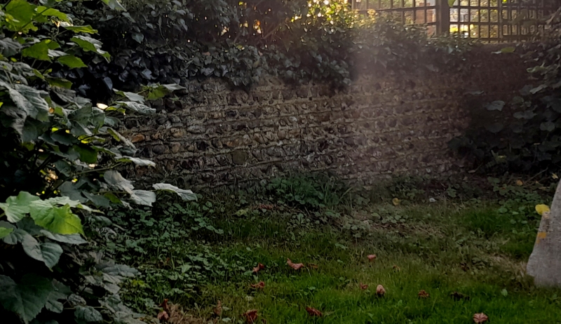
Churchyard wall
of St Mary's
SZ 9499 18/40A
II
2.
Low flint wall to churchyard, perhaps C18.
Listing NGR: SZ9488499860
External links are from the relevant listing authority and, where applicable, Wikidata. Wikidata IDs may be related buildings as well as this specific building. If you want to add or update a link, you will need to do so by editing the Wikidata entry.


Other nearby listed buildings
