Approximate Location Map
Large Map »
Latitude: 50.8908 / 50°53'26"N
Longitude: -0.3252 / 0°19'30"W
OS Eastings: 517890
OS Northings: 111477
OS Grid: TQ178114
Mapcode National: GBR HLS.2M2
Mapcode Global: FRA B66R.93S
Plus Code: 9C2XVMRF+8W
Entry Name: Gateway in the Garden to South of Gatewick
Listing Date: 9 May 1980
Grade: II
Source: Historic England
Source ID: 1354025
English Heritage Legacy ID: 298664
ID on this website: 101354025
Location: Steyning, Horsham, West Sussex, BN44
County: West Sussex
District: Horsham
Civil Parish: Steyning
Built-Up Area: Steyning
Traditional County: Sussex
Lieutenancy Area (Ceremonial County): West Sussex
Church of England Parish: Steyning St Andrew
Church of England Diocese: Chichester
Tagged with: Gate
STEYNING CHURCH LANE
1.
5404
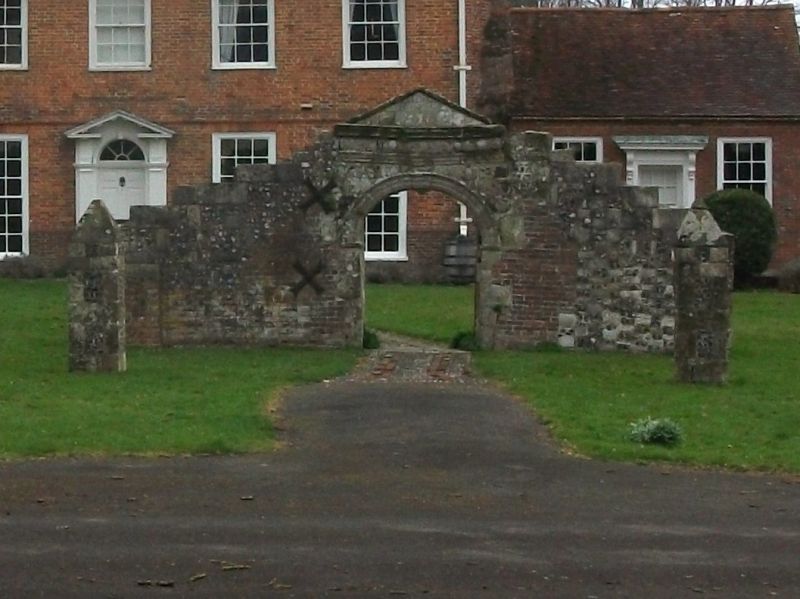
Gateway in the garden
to south of Gatewick
TQ 1711 24/59B
II GV
2.
C18. Originally a sort of ruin or folly, since converted into a gateway. Stone archway
with pediment, buttresses in flints and brick.
Listing NGR: TQ1788611473
External links are from the relevant listing authority and, where applicable, Wikidata. Wikidata IDs may be related buildings as well as this specific building. If you want to add or update a link, you will need to do so by editing the Wikidata entry.


Other nearby listed buildings
