Approximate Location Map
Large Map »
Latitude: 50.8876 / 50°53'15"N
Longitude: -0.3275 / 0°19'38"W
OS Eastings: 517740
OS Northings: 111119
OS Grid: TQ177111
Mapcode National: GBR HLS.81K
Mapcode Global: FRA B66R.G8G
Plus Code: 9C2XVMQF+22
Entry Name: 13, High Street
Listing Date: 9 May 1980
Grade: II
Source: Historic England
Source ID: 1180490
English Heritage Legacy ID: 298730
ID on this website: 101180490
Location: Steyning, Horsham, West Sussex, BN44
County: West Sussex
District: Horsham
Civil Parish: Steyning
Built-Up Area: Steyning
Traditional County: Sussex
Lieutenancy Area (Ceremonial County): West Sussex
Church of England Parish: Steyning St Andrew
Church of England Diocese: Chichester
Tagged with: Building
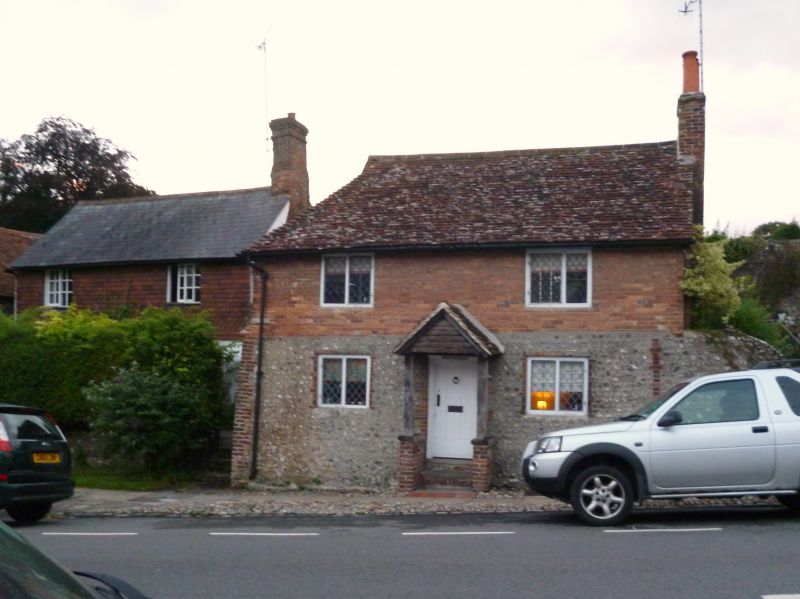
STEYNING HIGH STREET
1. (south-west side)
5404
No 13
TQ 1711 24/125
II GV
2.
C18. Two storeys. Two windows. Ground floor flints with red brick dressings
and quoins, above all red brick. Tiled roof. Casement windows with diamond-shaped
panes. Modern gabled porch.
Listing NGR: TQ1774011119
External links are from the relevant listing authority and, where applicable, Wikidata. Wikidata IDs may be related buildings as well as this specific building. If you want to add or update a link, you will need to do so by editing the Wikidata entry.


Other nearby listed buildings
