Approximate Location Map
Large Map »
Latitude: 50.8818 / 50°52'54"N
Longitude: -0.3035 / 0°18'12"W
OS Eastings: 519437
OS Northings: 110517
OS Grid: TQ194105
Mapcode National: GBR HLT.N2H
Mapcode Global: FRA B67R.ZHB
Plus Code: 9C2XVMJW+PH
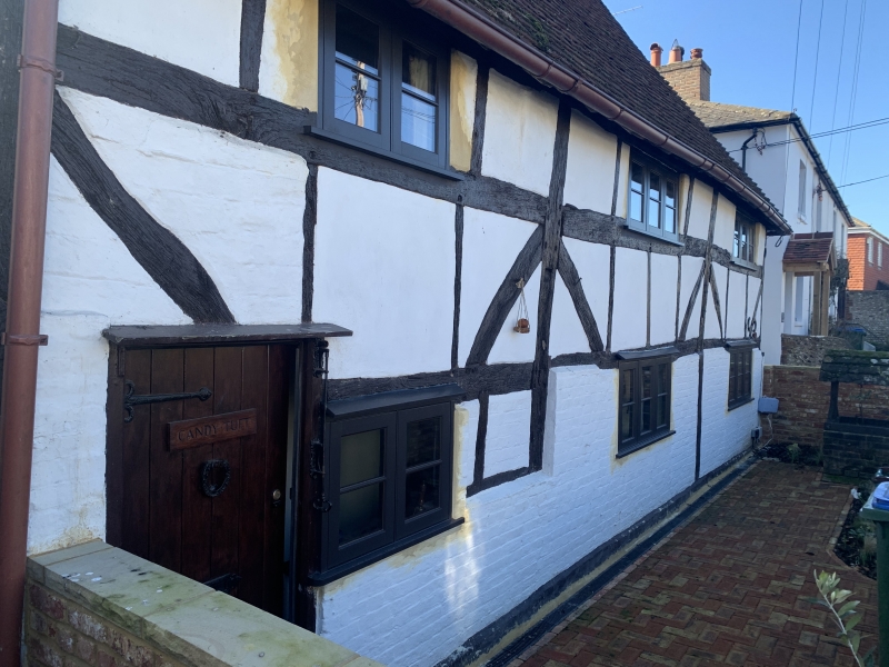
Entry Name: Candytuft
Listing Date: 15 March 1955
Grade: II
Source: Historic England
Source ID: 1354068
English Heritage Legacy ID: 298892
Also known as: Iberis
ID on this website: 101354068
Location: Upper Beeding, Horsham, West Sussex, BN44
County: West Sussex
District: Horsham
Civil Parish: Upper Beeding
Built-Up Area: Upper Beeding
Traditional County: Sussex
Lieutenancy Area (Ceremonial County): West Sussex
Church of England Parish: Beeding St Peter and Bramber St Nicholas
Church of England Diocese: Chichester
Tagged with: Building
1.
5404
TQ 1910
25/14
15.3.55
UPPER BEEDING
HIGH STREET
(south side)
Candytuft
II
GV
2.
Cl6 timber-framed building with plaster infilling and curved braces on first
floor, ground floor rebuilt in brick, now painted. Steeply-pitched hipped
tiled roof. Casement windows. Two storeys. Three windows.
Listing NGR: TQ1943710517
External links are from the relevant listing authority and, where applicable, Wikidata. Wikidata IDs may be related buildings as well as this specific building. If you want to add or update a link, you will need to do so by editing the Wikidata entry.


Other nearby listed buildings
