Approximate Location Map
Large Map »
Latitude: 50.9044 / 50°54'15"N
Longitude: -0.4103 / 0°24'37"W
OS Eastings: 511875
OS Northings: 112860
OS Grid: TQ118128
Mapcode National: GBR GK4.C2C
Mapcode Global: FRA B61Q.603
Plus Code: 9C2XWH3Q+QV
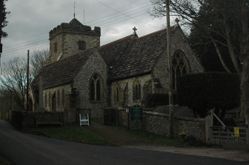
Entry Name: The Parish Church of St Mary
Listing Date: 15 March 1955
Grade: II*
Source: Historic England
Source ID: 1027198
English Heritage Legacy ID: 298941
ID on this website: 101027198
Location: St Mary's Church, Washington, Horsham, West Sussex, RH20
County: West Sussex
District: Horsham
Civil Parish: Washington
Traditional County: Sussex
Lieutenancy Area (Ceremonial County): West Sussex
Church of England Parish: Washington St Mary
Church of England Diocese: Chichester
Tagged with: Church building
WASHINGTON THE STREET
1. (north side)
5404
The Parish Church of
St Mary
TQ 11 SW 12/389 15.3.55
II*
2.
Chancel, nave with aisles, south porth and west tower. Tower C15. Otherwise
largely rebuilt by Gordon Hills in 1866-7, except for the north arcade of the
nave, which is C12.
Listing NGR: TQ1187512860
External links are from the relevant listing authority and, where applicable, Wikidata. Wikidata IDs may be related buildings as well as this specific building. If you want to add or update a link, you will need to do so by editing the Wikidata entry.


Other nearby listed buildings
