Approximate Location Map
Large Map »
Latitude: 50.9043 / 50°54'15"N
Longitude: -0.4108 / 0°24'38"W
OS Eastings: 511841
OS Northings: 112845
OS Grid: TQ118128
Mapcode National: GBR GK4.BYT
Mapcode Global: FRA B60Q.CS8
Plus Code: 9C2XWH3Q+PM
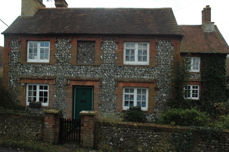
Entry Name: Church Farmhouse
Listing Date: 9 May 1980
Grade: II
Source: Historic England
Source ID: 1354096
English Heritage Legacy ID: 298945
ID on this website: 101354096
Location: Washington, Horsham, West Sussex, RH20
County: West Sussex
District: Horsham
Civil Parish: Washington
Traditional County: Sussex
Lieutenancy Area (Ceremonial County): West Sussex
Church of England Parish: Washington St Mary
Church of England Diocese: Chichester
Tagged with: Farmhouse
WASHINGTON THE STREET
1. (south side)
5404
Church Farmhouse
TQ 11 SW 12/392
II
2.
Two parallel ranges. North range early C19. Two storeys. Two windows and
one window-space. Faced with flints, set in galletting, with dripstones, long
and short quoins and window dressings of red brick. Tiled roof. Casement
windows. South wing later Cl9.
Listing NGR: TQ1184112845
External links are from the relevant listing authority and, where applicable, Wikidata. Wikidata IDs may be related buildings as well as this specific building. If you want to add or update a link, you will need to do so by editing the Wikidata entry.


Other nearby listed buildings
