Approximate Location Map
Large Map »
Latitude: 50.861 / 50°51'39"N
Longitude: -0.7119 / 0°42'42"W
OS Eastings: 490754
OS Northings: 107624
OS Grid: SU907076
Mapcode National: GBR DGH.T0X
Mapcode Global: FRA 96DT.NHJ
Plus Code: 9C2XV76Q+C7
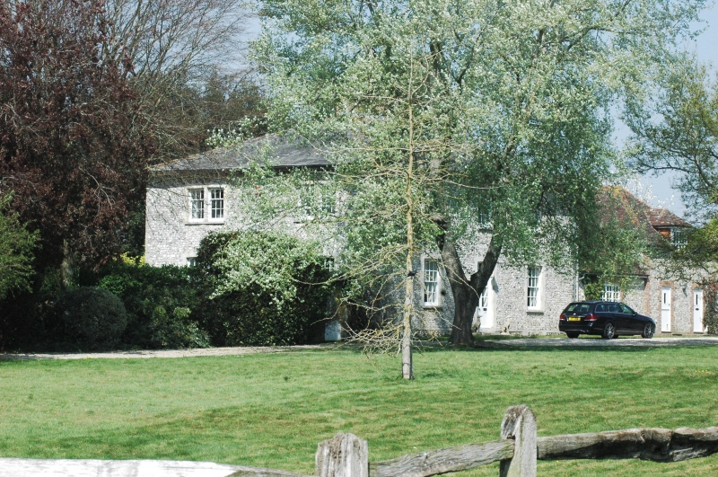
Entry Name: Priory Farmhouse
Listing Date: 28 January 1986
Grade: II
Source: Historic England
Source ID: 1026411
English Heritage Legacy ID: 300711
ID on this website: 101026411
Location: Boxgrove, Chichester, West Sussex, PO18
County: West Sussex
District: Chichester
Civil Parish: Boxgrove
Built-Up Area: Tangmere
Traditional County: Sussex
Lieutenancy Area (Ceremonial County): West Sussex
Church of England Parish: Boxgrove
Church of England Diocese: Chichester
Tagged with: Farmhouse
BOXGROVE THE STREET (east side)
SU 90 NW
14/66 Priory Farmhouse
-
- II
Square early C19 building. Two storeys. Three windows to each front. Faced
with flints with white brick dressings, quoins and modillion eaves cornice.
Hipped slate roof. Glazing bars intact. Doorway with rectangular fanlight
and flat hood over.
Listing NGR: SU9075407624
External links are from the relevant listing authority and, where applicable, Wikidata. Wikidata IDs may be related buildings as well as this specific building. If you want to add or update a link, you will need to do so by editing the Wikidata entry.


Other nearby listed buildings
