Approximate Location Map
Large Map »
Latitude: 50.7325 / 50°43'56"N
Longitude: -0.7973 / 0°47'50"W
OS Eastings: 484972
OS Northings: 93230
OS Grid: SZ849932
Mapcode National: GBR DHX.WSG
Mapcode Global: FRA 9764.R64
Plus Code: 9C2XP6J3+X3
Entry Name: Barn at Grablands Farm to the South East of Grablands House
Listing Date: 28 January 1986
Grade: II
Source: Historic England
Source ID: 1026259
English Heritage Legacy ID: 301057
ID on this website: 101026259
Location: Selsey, Chichester, West Sussex, PO20
County: West Sussex
District: Chichester
Civil Parish: Selsey
Built-Up Area: Selsey
Traditional County: Sussex
Lieutenancy Area (Ceremonial County): West Sussex
Church of England Parish: Selsey St Peter
Church of England Diocese: Chichester
Tagged with: Barn
SELSEY GRAB LANDS
SZ 8493/8593 (Previously listed under
Mill Lane)
41/841 Barn at Grablands Farm to
the south east of Grablands
house
-
- II
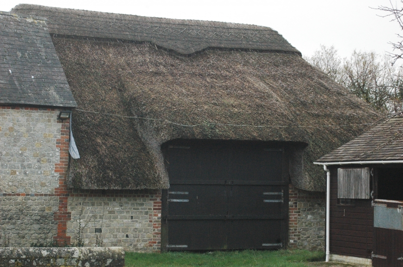
C18. Coursed stone with red brick dressings and quoins. The west end of the
roof is thatched, but the main portion is now slates.
Listing NGR: SZ8497293230
External links are from the relevant listing authority and, where applicable, Wikidata. Wikidata IDs may be related buildings as well as this specific building. If you want to add or update a link, you will need to do so by editing the Wikidata entry.


Other nearby listed buildings
