Approximate Location Map
Large Map »
Latitude: 50.9516 / 50°57'5"N
Longitude: -0.7509 / 0°45'3"W
OS Eastings: 487836
OS Northings: 117649
OS Grid: SU878176
Mapcode National: GBR DFG.8Z0
Mapcode Global: FRA 969L.K8B
Plus Code: 9C2XX62X+JJ
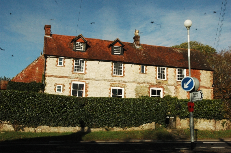
Entry Name: The High House
Listing Date: 18 June 1959
Grade: II
Source: Historic England
Source ID: 1232194
English Heritage Legacy ID: 301610
ID on this website: 101232194
Location: Cocking, Chichester, West Sussex, GU29
County: West Sussex
District: Chichester
Civil Parish: Cocking
Built-Up Area: Cocking
Traditional County: Sussex
Lieutenancy Area (Ceremonial County): West Sussex
Church of England Parish: Cocking with West Lavington
Church of England Diocese: Chichester
Tagged with: House
SU 8617-8717 COCKING THE STREET
(west side)
29/16 The High House
18.6.59
GV II
C18. Clunch with red brick dressings, quoins and stringcourse. North wall uncoursed
stone rubble and flints. Tiled roof. Two storwys and attic. Four windows.
Sashes with glazing bars intact on first floor. Two gabled dormers.
Listing NGR: SU8783717650
External links are from the relevant listing authority and, where applicable, Wikidata. Wikidata IDs may be related buildings as well as this specific building. If you want to add or update a link, you will need to do so by editing the Wikidata entry.


Other nearby listed buildings
