Approximate Location Map
Large Map »
Latitude: 51.0573 / 51°3'26"N
Longitude: -0.1067 / 0°6'24"W
OS Eastings: 532785
OS Northings: 130365
OS Grid: TQ327303
Mapcode National: GBR KML.PTK
Mapcode Global: FRA B6NB.B7S
Plus Code: 9C3X3V4V+W8
Entry Name: Lullings
Listing Date: 28 October 1957
Grade: II
Source: Historic England
Source ID: 1025790
English Heritage Legacy ID: 302281
ID on this website: 101025790
Location: Mid Sussex, RH17
County: West Sussex
District: Mid Sussex
Civil Parish: Ardingly
Traditional County: Sussex
Lieutenancy Area (Ceremonial County): West Sussex
Church of England Parish: Ardingly
Church of England Diocese: Chichester
Tagged with: Building
ARDINGLY BALCOMBE ROAD
1.
5405
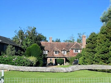
Lullings
TQ 33 SW 6/431 28.10.57
II
2.
The original portion is a C15 timber-framed building, now tile-hung. Half-hipped
tiled roof. Casement windows, Two storeys. Five windows. Crown-post roof inside.
Modem L wing to north east.
Listing NGR: TQ3278530365
External links are from the relevant listing authority and, where applicable, Wikidata. Wikidata IDs may be related buildings as well as this specific building. If you want to add or update a link, you will need to do so by editing the Wikidata entry.


Other nearby listed buildings
