Approximate Location Map
Large Map »
Latitude: 50.9236 / 50°55'25"N
Longitude: -0.1659 / 0°9'57"W
OS Eastings: 529007
OS Northings: 115398
OS Grid: TQ290153
Mapcode National: GBR JMY.0WJ
Mapcode Global: FRA B6JN.R64
Plus Code: 9C2XWRFM+FM
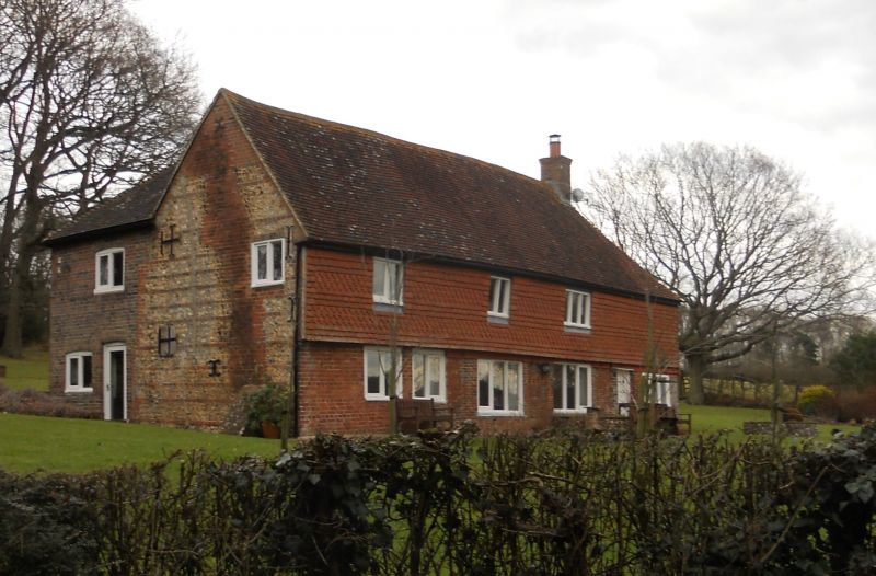
Entry Name: Bearstakes
Listing Date: 11 May 1983
Grade: II
Source: Historic England
Source ID: 1025648
English Heritage Legacy ID: 302655
ID on this website: 101025648
Location: Mid Sussex, BN6
County: West Sussex
District: Mid Sussex
Civil Parish: Hurstpierpoint and Sayers Common
Built-Up Area: Hurstpierpoint
Traditional County: Sussex
Lieutenancy Area (Ceremonial County): West Sussex
Church of England Parish: Hurstpierpoint
Church of England Diocese: Chichester
Tagged with: Building
HURSTPIERPOINT NEW WAY LANE
1.
5405
Bears takes
TQ 21 NE 19/130
II
2.
C17. Two storeys. Three windows. Ground floor red brick and grey headers,
above hung with fishscale tiles. Tiles roof. Casement windows.
Listing NGR: TQ2900715398
External links are from the relevant listing authority and, where applicable, Wikidata. Wikidata IDs may be related buildings as well as this specific building. If you want to add or update a link, you will need to do so by editing the Wikidata entry.


Other nearby listed buildings
