Approximate Location Map
Large Map »
Latitude: 54.8421 / 54°50'31"N
Longitude: -1.4682 / 1°28'5"W
OS Eastings: 434252
OS Northings: 549831
OS Grid: NZ342498
Mapcode National: GBR LD5G.Y0
Mapcode Global: WHD5J.FK39
Plus Code: 9C6WRGRJ+VP
Entry Name: Kepier Almshouses
Listing Date: 26 April 1950
Grade: II
Source: Historic England
Source ID: 1184826
English Heritage Legacy ID: 303178
ID on this website: 101184826
Location: Houghton-le-Spring, Sunderland, Tyne and Wear, DH4
County: Sunderland
Electoral Ward/Division: Houghton
Parish: Non Civil Parish
Built-Up Area: Houghton-le-Spring
Traditional County: Durham
Lieutenancy Area (Ceremonial County): Tyne and Wear
Church of England Parish: Houghton-le-Spring
Church of England Diocese: Durham
Tagged with: Almshouse
This list entry was subject to a Minor Amendment on 13/03/2020
NZ34NW
7/22
HOUGHTON-LE-SPRING
Houghton-le-Spring
Church Street (north side)
Kepier Almshouses
[Formerly listed as Davenport and Lilburne Almshouses, CHURCH STREET (north side)]
26.4.50
G.V.
II
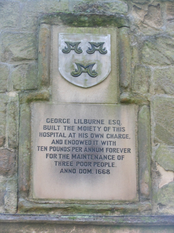
Almshouses, later three then two separate dwellings. Dated 1668, restored c.1978. Coursed squared sandstone; roof pantiled.
E-plan: one cottage flanked by two cottages. One storey, five bays. Central door under flattened Tudor arch in stop-chamfered surround with triangular-stopped label mould; either side are three-light mullioned windows with similar moulds. Returns to street have door in angle and one three-light window; gables to street have three-light window: all similar to central house. Gable peaks contain inscriptions and shields: the north commemorating George Lilburn's building of half of the hospital in 1668, the south an endowment from the Reverend William Sharp. Flat stone gable coping and one transverse ridge chimney on each return.
Listing NGR: NZ3425249831
External links are from the relevant listing authority and, where applicable, Wikidata. Wikidata IDs may be related buildings as well as this specific building. If you want to add or update a link, you will need to do so by editing the Wikidata entry.


Other nearby listed buildings
