Approximate Location Map
Large Map »
Latitude: 55.0009 / 55°0'3"N
Longitude: -1.6029 / 1°36'10"W
OS Eastings: 425502
OS Northings: 567442
OS Grid: NZ255674
Mapcode National: GBR SQS.NJ
Mapcode Global: WHC3K.BKZL
Plus Code: 9C7W292W+9V
Entry Name: Castle Farmhouse
Listing Date: 8 May 1981
Grade: II
Source: Historic England
Source ID: 1024934
English Heritage Legacy ID: 304442
ID on this website: 101024934
Location: West Jesmond, Newcastle upon Tyne, Tyne and Wear, NE2
County: Newcastle upon Tyne
Electoral Ward/Division: Dene
Parish: Non Civil Parish
Built-Up Area: Newcastle upon Tyne
Traditional County: Northumberland
Lieutenancy Area (Ceremonial County): Tyne and Wear
Church of England Parish: High Heaton, Newcastle St Francis
Church of England Diocese: Newcastle
Tagged with: Farmhouse
NZ 26NE NEWCASTLE UPON TYNE CASTLE FARM ROAD
(south side)
9/137
8/5/81 Castle Farmhouse
G.V. II
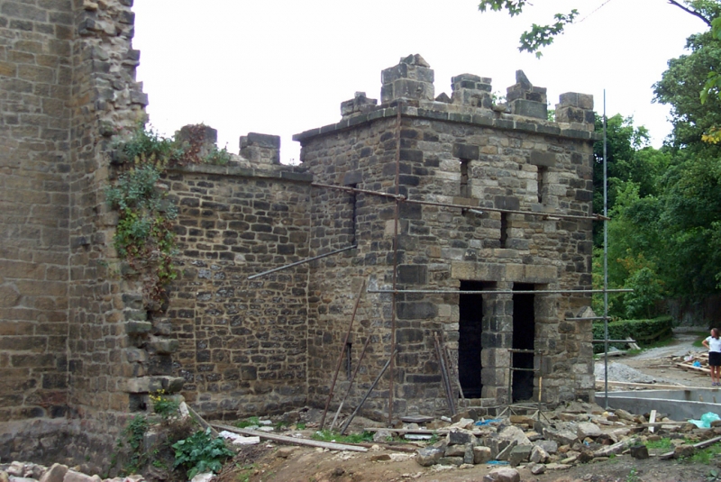
Folly, later farmhouse. Late C18. Coursed squared sandstone with irregular large
quoins and ashlar dressings; rendered rear addition; Welsh slate roof. 3½ storeys,
2 bays . Gothic style. 4-light wood mullioned-and-transomed window at left; at
right recessed segmental-headed arch containing tripartite stone-mullioned window
and lunette with wood mullions and transoms; small casement with chamfered surround
above. Battlemented parapet. Jagged wall breaks forward at right with lower
battlemented wall extending in line with house. Entrance in left return: gabled
porch with stone arch and wood seats; boarded door. Chamfered surrounds to 2
square windows on 2 upper floors and a blind panel below pent roof; monopitch roof
slopes down from battlemented front. Interior shows one late C18 chimney piece
with cast iron grate and one C19 also with iron grate. Historical note: this
property belonged to Dr. Headlam, who lived in Jesmond Dene House across the valley.
It was known as Heaton High Laws Farm, then as Knox's Farm.
Listing NGR: NZ2550267442
External links are from the relevant listing authority and, where applicable, Wikidata. Wikidata IDs may be related buildings as well as this specific building. If you want to add or update a link, you will need to do so by editing the Wikidata entry.


Other nearby listed buildings
