Approximate Location Map
Large Map »
Latitude: 54.9824 / 54°58'56"N
Longitude: -1.6214 / 1°37'17"W
OS Eastings: 424324
OS Northings: 565380
OS Grid: NZ243653
Mapcode National: GBR SN4.4X
Mapcode Global: WHC3R.2156
Plus Code: 9C6WX9JH+XC
Entry Name: 1-17, Framlington Place
Listing Date: 30 March 1987
Grade: II
Source: Historic England
Source ID: 1355221
English Heritage Legacy ID: 304561
ID on this website: 101355221
Location: Spital Tongues, Newcastle upon Tyne, Tyne and Wear, NE2
County: Newcastle upon Tyne
Electoral Ward/Division: Wingrove
Parish: Non Civil Parish
Built-Up Area: Newcastle upon Tyne
Traditional County: Northumberland
Lieutenancy Area (Ceremonial County): Tyne and Wear
Church of England Parish: Newcastle St Luke
Church of England Diocese: Newcastle
Tagged with: Building
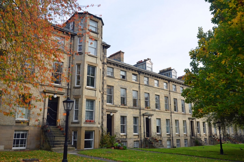
NZ 2465 SW NEWCASTLE UPON TYNE FRAMLINGTON PLACE
(north side)
13/248 Nos. 1-17 consecutive
G.V. II
Terrace of houses. Circa 1850. Grey brick with ashlar basement, plinth and
dressings; Welsh slate roof. Nos. 8, 9 and 10 project with quoins. Basements
to right part of terrace, Nos. 1-10; 3 storeys except for 4-storey canted bay to
No. 8; houses vary from 3 to 6 bays. Steps, more at right, to 4-panelled doors
and overlights in raised stone surrounds with prominent cornices; Tuscan porch
to No. 16. Wedge stone lintels to margined sashes with ground floor aprons and
projecting stone sills; canted bay windows to Nos. 16 and 17 at left end; entrance
to No. 1 in set-back open porch at right; and to No. 17 in 3-bay left return.
Sill bands to first and second floors; dentilled cornice. Low-pitched hipped
roof has ashlar-corniced brick chimneys. Cast iron railings to steps of Nos.
1-13; with tied diagonal bars Nos. 1-7, scrolled balusters Nos. 8-13.
Listing NGR: NZ2432465380
External links are from the relevant listing authority and, where applicable, Wikidata. Wikidata IDs may be related buildings as well as this specific building. If you want to add or update a link, you will need to do so by editing the Wikidata entry.


Other nearby listed buildings
