Approximate Location Map
Large Map »
Latitude: 54.9681 / 54°58'5"N
Longitude: -1.6116 / 1°36'41"W
OS Eastings: 424960
OS Northings: 563791
OS Grid: NZ249637
Mapcode National: GBR SPK.3L
Mapcode Global: WHC3R.6DT6
Plus Code: 9C6WX99Q+68
Entry Name: Turnbull's Warehouse
Listing Date: 30 March 1987
Grade: II
Source: Historic England
Source ID: 1325543
English Heritage Legacy ID: 304799
Also known as: Turnbull Building
ID on this website: 101325543
Location: Newcastle upon Tyne, Tyne and Wear, NE1
County: Newcastle upon Tyne
Electoral Ward/Division: Westgate
Parish: Non Civil Parish
Built-Up Area: Newcastle upon Tyne
Traditional County: Northumberland
Lieutenancy Area (Ceremonial County): Tyne and Wear
Church of England Parish: St Nicholas Newcastle-upon-Tyne
Church of England Diocese: Newcastle
Tagged with: Warehouse
NZ 2463 NE NEWCASTLE UPON TYNE QUEENS LANE
(west side)
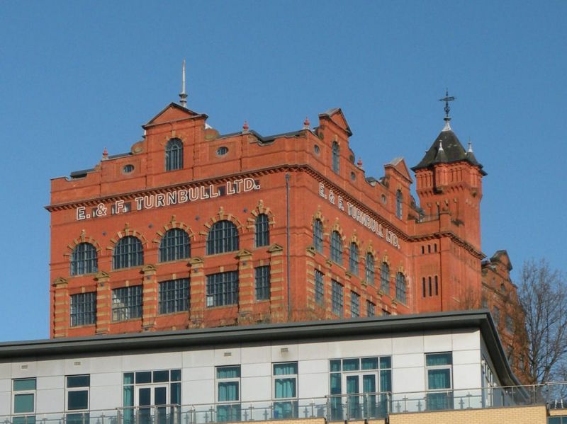
23/469 Turnbull's Warehouse
G.V. II
Warehouse. 1888 north block; 1897 additions to south; 1898 tower. By F. W. Rich
for Robinson and Co., printers. Brick with ashlar dressings; Welsh slate roof.
5 storeys at right, 6 at left, and attics; 6:2:7 bays. Near-central 2-bay tower
has groups of 3 slit windows on each floor; panelled and blind-arcaded top floor;
wide windows, those in left section round-headed on top floor with brick-and-
stone keyed arches. Bays defined by buttresses, those of the top floors at left
with ashlar bands. Sill bands. Right section and lower left windows have
cambered brick arches with keys; sill bands. Cornices on second floor of left
section. Top cornice all around, dentilled at left and on tower. Shaped attic
gables, with central pediments, have round-headed and oeil-de boeuf windows
between pilasters. High pyramidal tower roof has small octagonal spirelets, all
with swept eaves, over blind oriels. Central lead-covered ogee hipped roof.
Listing NGR: NZ2496063791
External links are from the relevant listing authority and, where applicable, Wikidata. Wikidata IDs may be related buildings as well as this specific building. If you want to add or update a link, you will need to do so by editing the Wikidata entry.


Other nearby listed buildings
