Approximate Location Map
Large Map »
Latitude: 54.9693 / 54°58'9"N
Longitude: -1.6067 / 1°36'24"W
OS Eastings: 425276
OS Northings: 563921
OS Grid: NZ252639
Mapcode National: GBR SQ8.BQ
Mapcode Global: WHC3R.9C4B
Plus Code: 9C6WX99V+P8
Entry Name: Princes Buildings
Listing Date: 30 March 1987
Grade: II
Source: Historic England
Source ID: 1107170
English Heritage Legacy ID: 304801
ID on this website: 101107170
Location: Battle Field, Newcastle upon Tyne, Tyne and Wear, NE1
County: Newcastle upon Tyne
Electoral Ward/Division: Ouseburn
Parish: Non Civil Parish
Built-Up Area: Newcastle upon Tyne
Traditional County: Northumberland
Lieutenancy Area (Ceremonial County): Tyne and Wear
Church of England Parish: Newcastle Christ Church
Church of England Diocese: Newcastle
Tagged with: Building
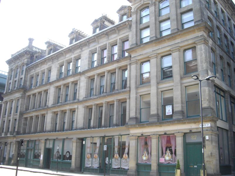
NZ 2563 NW NEWCASTLE UPON TYNE QUEEN STREET
(north side)
24/350 Nos. 1 to 23 odd
(Princes Buildings)
G.V. II
Offices. Circa 1863. Sandstone ashlar; Welsh slate roof. Complete block. 4
storeys. The chief architectural elevation comprises Nos. 11-23 (odd) Queen
Street. No. 11 is of six bays canted in the centre so that the main elevation
reads 6.4.3.4.3 making a balanced composition. Ground floor articulated by plain
pilasters with original shopfronts between. First and second floors have giant
pilasters to Nos. 11 and 23, Tuscan columns with heavy entablature to Nos. 13-21.
Fourth and fifth floors giant pilasters again to Nos. 11 and 23. Central houses
have moulded architraves to fourth floor windows. Heavy cornice on brackets,
pedimented dormer. Pierced parapets to Nos. 11 and 23. Large stacks with
bracketed cornices. Roofs not visible from street. Nos. 3-9 (odd) have a plainer
elevation with a fourteen-bay arcade on the first and second floors. No. 1 has
a classical treatment with a canted corner of 3.1.1.1.3 bays to Akenside Hill.
The roofline has been interfered with by the Tyne Bridge. East flank to King
Street and rear facade to Akenside Hill have a lesser architectural character.
No. 23 Queen Street frames an important view of All Saints Church together with
No. 25 (q.v.).
Listing NGR: NZ2527663921
External links are from the relevant listing authority and, where applicable, Wikidata. Wikidata IDs may be related buildings as well as this specific building. If you want to add or update a link, you will need to do so by editing the Wikidata entry.


Other nearby listed buildings
