Approximate Location Map
Large Map »
Latitude: 52.1889 / 52°11'20"N
Longitude: -1.8737 / 1°52'25"W
OS Eastings: 408728
OS Northings: 254524
OS Grid: SP087545
Mapcode National: GBR 3K8.M45
Mapcode Global: VHB0G.G7ST
Plus Code: 9C4W54QG+HG
Entry Name: Wixford Bridge
Listing Date: 13 December 1984
Grade: II
Source: Historic England
Source ID: 1355351
English Heritage Legacy ID: 305028
ID on this website: 101355351
Location: Wixford, Stratford-on-Avon, Warwickshire, B49
County: Warwickshire
District: Stratford-on-Avon
Civil Parish: Wixford
Traditional County: Warwickshire
Lieutenancy Area (Ceremonial County): Warwickshire
Church of England Parish: Arrow with Weethley
Church of England Diocese: Coventry
Tagged with: Bridge
SP05SE WIXFORD
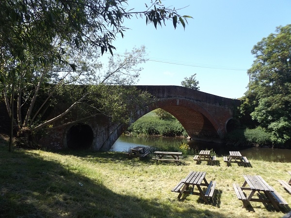
5/16 Wixford Bridge
- II
Bridge. Late C18. Red brick and stone dressings. Single almost semi-
circular span with circular flood opening at each end and hump back roadway.
String course at road level. Splayed abutments. Late C20 parapets.
Listing NGR: SP0872854524
External links are from the relevant listing authority and, where applicable, Wikidata. Wikidata IDs may be related buildings as well as this specific building. If you want to add or update a link, you will need to do so by editing the Wikidata entry.


Other nearby listed buildings
