Approximate Location Map
Large Map »
Latitude: 52.2421 / 52°14'31"N
Longitude: -1.331 / 1°19'51"W
OS Eastings: 445778
OS Northings: 260648
OS Grid: SP457606
Mapcode National: GBR 7QQ.D9Y
Mapcode Global: VHCV8.WX72
Plus Code: 9C4W6MR9+RJ
Entry Name: Napton Bottom Lock, Oxford Canal
Listing Date: 21 April 1986
Grade: II
Source: Historic England
Source ID: 1024442
English Heritage Legacy ID: 305640
ID on this website: 101024442
Location: Napton on the Hill, Stratford-on-Avon, Warwickshire, CV47
County: Warwickshire
District: Stratford-on-Avon
Civil Parish: Napton on the Hill
Traditional County: Warwickshire
Lieutenancy Area (Ceremonial County): Warwickshire
Church of England Parish: Napton-on-the-Hill St Lawrence
Church of England Diocese: Coventry
NAPTON ON THE HILL FOLLY LANE
SP46SE
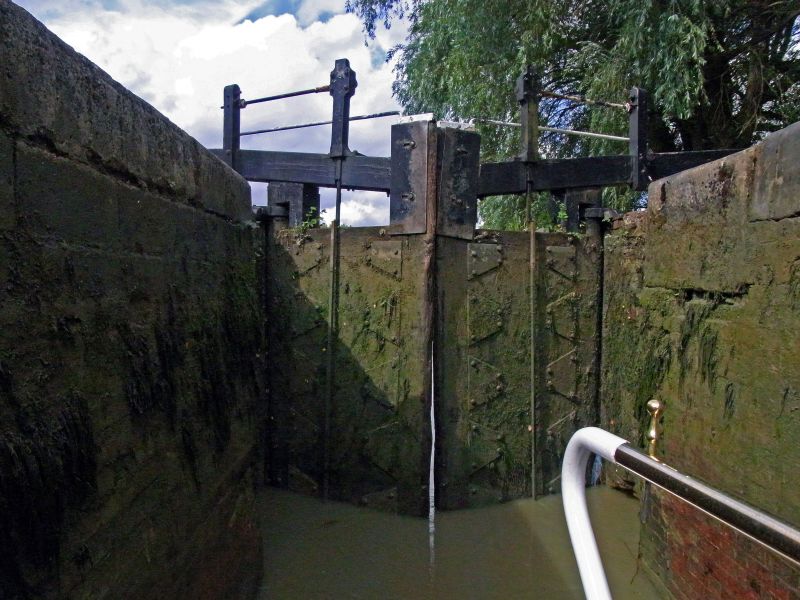
2/64 Napton Bottom Lock, Oxford
Canal
GV II
Canal lock. Late C18/early C19, with some later restoration. English bond brick
with stone coping. Double and single wooden lock gates with wooden beans.
Included for group value.
Listing NGR: SP4576460652
External links are from the relevant listing authority and, where applicable, Wikidata. Wikidata IDs may be related buildings as well as this specific building. If you want to add or update a link, you will need to do so by editing the Wikidata entry.


Other nearby listed buildings
