Approximate Location Map
Large Map »
Latitude: 52.2807 / 52°16'50"N
Longitude: -1.5864 / 1°35'11"W
OS Eastings: 428312
OS Northings: 264812
OS Grid: SP283648
Mapcode National: GBR 5M4.V2G
Mapcode Global: VHBXH.GX5Z
Plus Code: 9C4W7CJ7+7C
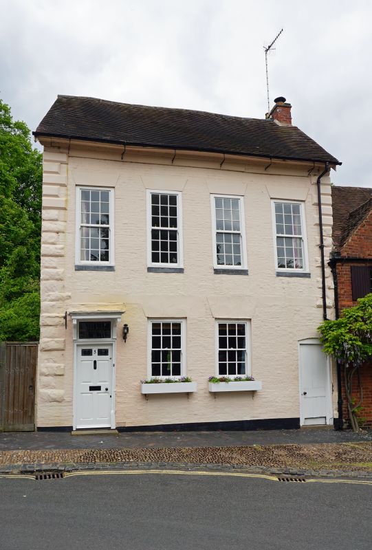
Entry Name: 5, Castle Street
Listing Date: 19 March 1973
Grade: II
Source: Historic England
Source ID: 1035486
English Heritage Legacy ID: 307415
ID on this website: 101035486
Location: Warwick, Warwickshire, CV34
County: Warwickshire
District: Warwick
Civil Parish: Warwick
Built-Up Area: Warwick
Traditional County: Warwickshire
Lieutenancy Area (Ceremonial County): Warwickshire
Church of England Parish: Warwick St Mary
Church of England Diocese: Coventry
Tagged with: Building
1.
1781 CASTLE STREET
(East Side)
No 5
SP 2064 NW 1/11
II GV
2.
C18. Colour washed brickwork, old tiled roof. 2 storeys, chamfered stone
quoins, first floor band. 4 flush sashes with glazing bars in cased frames.
6 panel door under bracketed hood. Cornice. Painted stone window heads.
Nos 5, 7 and 9 form a group.
Listing NGR: SP2831264811
External links are from the relevant listing authority and, where applicable, Wikidata. Wikidata IDs may be related buildings as well as this specific building. If you want to add or update a link, you will need to do so by editing the Wikidata entry.


Other nearby listed buildings
