Approximate Location Map
Large Map »
Latitude: 52.2805 / 52°16'49"N
Longitude: -1.591 / 1°35'27"W
OS Eastings: 427999
OS Northings: 264790
OS Grid: SP279647
Mapcode National: GBR 5M4.SPW
Mapcode Global: VHBXH.CYR3
Plus Code: 9C4W7CJ5+6J
Entry Name: Gazebo in Garden of Lord Leicesters Hospital
Listing Date: 10 January 1953
Grade: II
Source: Historic England
Source ID: 1035442
English Heritage Legacy ID: 307510
ID on this website: 101035442
Location: Warwick, Warwickshire, CV34
County: Warwickshire
District: Warwick
Civil Parish: Warwick
Built-Up Area: Warwick
Traditional County: Warwickshire
Lieutenancy Area (Ceremonial County): Warwickshire
Church of England Parish: Warwick St Mary
Church of England Diocese: Coventry
Tagged with: Gazebo
1.
1781 HIGH STREET
(North Side)
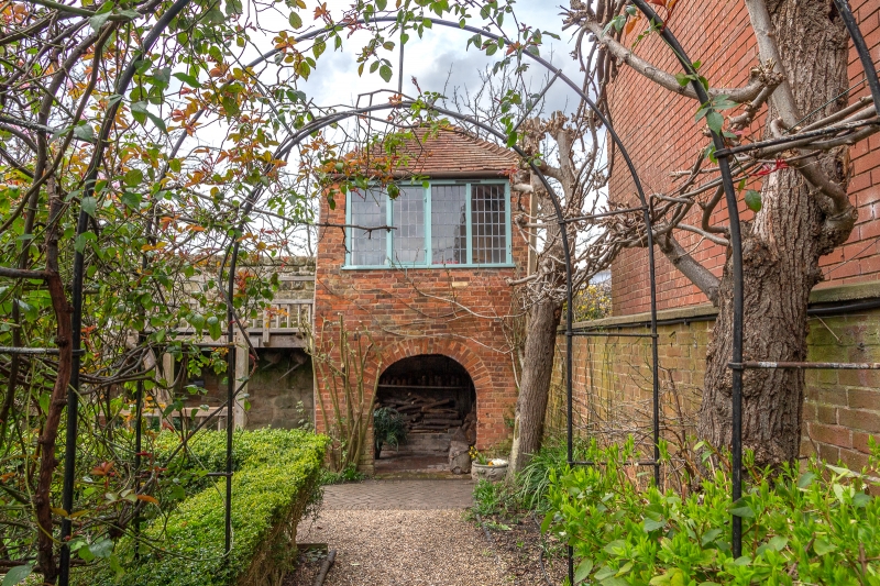
Gazebo in garden
of Lord Leicester's
Hospital
SP 2864 NW 1/292 10.1.53.
II
2.
Square plan C18 gazebo of red brick with conical tiled roof.
Listing NGR: SP2799964790
External links are from the relevant listing authority and, where applicable, Wikidata. Wikidata IDs may be related buildings as well as this specific building. If you want to add or update a link, you will need to do so by editing the Wikidata entry.


Other nearby listed buildings
