Approximate Location Map
Large Map »
Latitude: 52.2823 / 52°16'56"N
Longitude: -1.5855 / 1°35'7"W
OS Eastings: 428376
OS Northings: 264986
OS Grid: SP283649
Mapcode National: GBR 5M4.V9N
Mapcode Global: VHBXH.GWPS
Plus Code: 9C4W7CJ7+WR
Entry Name: Garden Boundary Wall of Number 37
Listing Date: 19 March 1973
Grade: II
Source: Historic England
Source ID: 1184616
English Heritage Legacy ID: 307523
ID on this website: 101184616
Location: Warwick, Warwickshire, CV34
County: Warwickshire
District: Warwick
Civil Parish: Warwick
Built-Up Area: Warwick
Traditional County: Warwickshire
Lieutenancy Area (Ceremonial County): Warwickshire
Church of England Parish: Warwick St Mary
Church of England Diocese: Coventry
Tagged with: Wall
1.
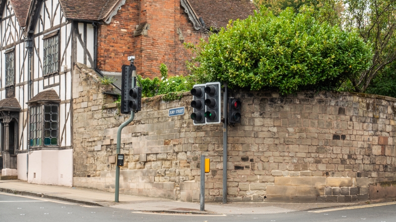
1781 JURY STREET
(North Side)
Garden Boundary
Wall of No 37
SP 2864 NW 1/117
SP 2865 SW 3/117
II GV
2.
Sandstone boundary wall to garden probably dates from C18.
All the listed buildings on the north side, from Nos 17 to 37,
form a group.
Listing NGR: SP2837664985
External links are from the relevant listing authority and, where applicable, Wikidata. Wikidata IDs may be related buildings as well as this specific building. If you want to add or update a link, you will need to do so by editing the Wikidata entry.


Other nearby listed buildings
