Approximate Location Map
Large Map »
Latitude: 52.2821 / 52°16'55"N
Longitude: -1.5891 / 1°35'20"W
OS Eastings: 428130
OS Northings: 264967
OS Grid: SP281649
Mapcode National: GBR 5M4.T8F
Mapcode Global: VHBXH.DWSW
Plus Code: 9C4W7CJ6+V9
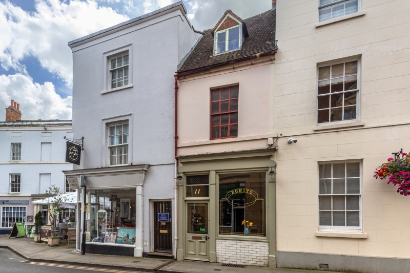
Entry Name: 11, Old Square
Listing Date: 19 March 1973
Grade: II
Source: Historic England
Source ID: 1364830
English Heritage Legacy ID: 307600
ID on this website: 101364830
Location: Warwick, Warwickshire, CV34
County: Warwickshire
District: Warwick
Civil Parish: Warwick
Built-Up Area: Warwick
Traditional County: Warwickshire
Lieutenancy Area (Ceremonial County): Warwickshire
Church of England Parish: Warwick St Mary
Church of England Diocese: Coventry
Tagged with: Building
1.
1781 OLD SQUARE
(South West Side)
No 11
SP 2864 NW 1/475
II GV
2.
C18. Stucco, machine tiled roof with gabled dormer casement. First floor
sash in reveal with glazing bars, sill band. Cornice. C19 shop with slender
pilasters.
Nos 5 to 13 (odd) form a group
Listing NGR: SP2813064967
External links are from the relevant listing authority and, where applicable, Wikidata. Wikidata IDs may be related buildings as well as this specific building. If you want to add or update a link, you will need to do so by editing the Wikidata entry.


Other nearby listed buildings
