Approximate Location Map
Large Map »
Latitude: 52.2828 / 52°16'57"N
Longitude: -1.5832 / 1°34'59"W
OS Eastings: 428528
OS Northings: 265038
OS Grid: SP285650
Mapcode National: GBR 5M4.VZ4
Mapcode Global: VHBXH.HWWF
Plus Code: 9C4W7CM8+4P
Entry Name: 38 40, Smith Street
Listing Date: 19 March 1973
Grade: II
Source: Historic England
Source ID: 1035374
English Heritage Legacy ID: 307638
ID on this website: 101035374
Location: Warwick, Warwickshire, CV34
County: Warwickshire
District: Warwick
Civil Parish: Warwick
Built-Up Area: Warwick
Traditional County: Warwickshire
Lieutenancy Area (Ceremonial County): Warwickshire
Church of England Parish: Warwick St Nicholas
Church of England Diocese: Coventry
Tagged with: Building
1.
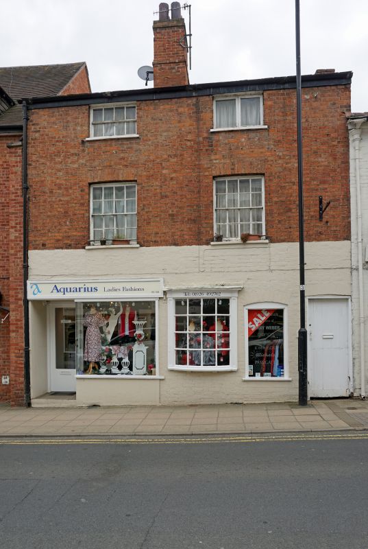
1781 SMITH STREET
(South Side)
Nos 38 and 40
SP 2865 SE 4/220
II GV
2.
Early C19. Listed partly on account of small segmental bow window. Red
brick front wall of 3 storeys. 2 sashes with glazing bars, flat arches.
Modern shop on left with projecting fascia panel.
Nos 38, 40, 42 form a group
Listing NGR: SP2852865038
External links are from the relevant listing authority and, where applicable, Wikidata. Wikidata IDs may be related buildings as well as this specific building. If you want to add or update a link, you will need to do so by editing the Wikidata entry.


Other nearby listed buildings
