Approximate Location Map
Large Map »
Latitude: 52.2832 / 52°16'59"N
Longitude: -1.5824 / 1°34'56"W
OS Eastings: 428585
OS Northings: 265085
OS Grid: SP285650
Mapcode National: GBR 5M4.W6S
Mapcode Global: VHBXH.JW93
Plus Code: 9C4W7CM9+72
Entry Name: 55, Smith Street
Listing Date: 19 March 1973
Grade: II
Source: Historic England
Source ID: 1185260
English Heritage Legacy ID: 307653
ID on this website: 101185260
Location: Warwick, Warwickshire, CV34
County: Warwickshire
District: Warwick
Civil Parish: Warwick
Built-Up Area: Warwick
Traditional County: Warwickshire
Lieutenancy Area (Ceremonial County): Warwickshire
Church of England Parish: Warwick St Nicholas
Church of England Diocese: Coventry
Tagged with: Building
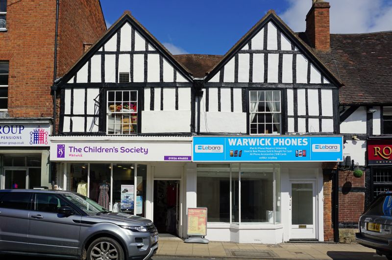
1.
1781 SMITH STREET
(North Side)
No 55
SP 2865 SE 4/240
II GV
2.
Late C16 2 storey house with identical twin gables of slender vertical
studding, having one sash window each. Large plate glass shopfronts.
Roof of well weathered machine tiles. VCH, viii, p.443.
Nos 55 to 61 (odd) including Nos 57A and 59A, form a group
Listing NGR: SP2858565084
External links are from the relevant listing authority and, where applicable, Wikidata. Wikidata IDs may be related buildings as well as this specific building. If you want to add or update a link, you will need to do so by editing the Wikidata entry.


Other nearby listed buildings
