Approximate Location Map
Large Map »
Latitude: 52.2772 / 52°16'37"N
Longitude: -1.593 / 1°35'34"W
OS Eastings: 427867
OS Northings: 264416
OS Grid: SP278644
Mapcode National: GBR 5MB.628
Mapcode Global: VHBXP.B1Q4
Plus Code: 9C4W7CG4+VR
Entry Name: 109 111, West Street
Listing Date: 19 March 1973
Grade: II
Source: Historic England
Source ID: 1035358
English Heritage Legacy ID: 307690
ID on this website: 101035358
Location: Warwick, Warwickshire, CV34
County: Warwickshire
District: Warwick
Civil Parish: Warwick
Built-Up Area: Warwick
Traditional County: Warwickshire
Lieutenancy Area (Ceremonial County): Warwickshire
Church of England Parish: Warwick St Paul
Church of England Diocese: Coventry
Tagged with: Building
1.
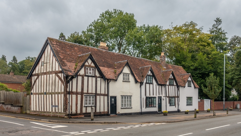
1781 WEST STREET
(South East Side)
Nos 109 & 111
SP 2764 8/264
II GV
2.
C17, restored and altered. Cement rendering on timber framework exposed
on left. 2 storeys, 4 flush gables. 4 flush casement windows.
Nos 105 to 111(odd) form a group
Listing NGR: SP2786764415
External links are from the relevant listing authority and, where applicable, Wikidata. Wikidata IDs may be related buildings as well as this specific building. If you want to add or update a link, you will need to do so by editing the Wikidata entry.


Other nearby listed buildings
