Approximate Location Map
Large Map »
Latitude: 52.341 / 52°20'27"N
Longitude: -1.5771 / 1°34'37"W
OS Eastings: 428905
OS Northings: 271514
OS Grid: SP289715
Mapcode National: GBR 5LK.B29
Mapcode Global: VHBX9.MF28
Plus Code: 9C4W8CRF+94
Entry Name: 59-63, Warwick Road
Listing Date: 24 July 1992
Grade: II
Source: Historic England
Source ID: 1364918
English Heritage Legacy ID: 307862
ID on this website: 101364918
Location: Kenilworth, Warwick, Warwickshire, CV8
County: Warwickshire
District: Warwick
Civil Parish: Kenilworth
Built-Up Area: Kenilworth
Traditional County: Warwickshire
Lieutenancy Area (Ceremonial County): Warwickshire
Church of England Parish: Kenilworth St John the Evangelist
Church of England Diocese: Coventry
Tagged with: Building
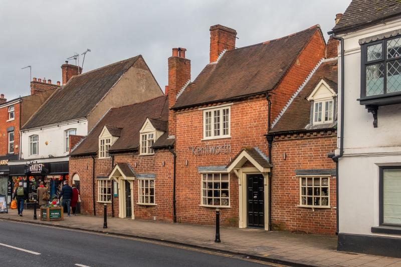
KENILWORTH
WARWICK ROAD
SP2871-2971
9/10003 Nos 59 - 63
GV II
Group of 3 cottages. Late C18 - early C19 but partly with c1700 core.
Some internal timber framing; red brick with renewed tile roofs. 1
storey and attic and 2 storeys; total of 4 windows to upper floor.
Casements with glazing bars; dentilled eaves. 59 and 61 (on left):
flush-panelled door under round arch to side passage on far left. C20
panelled door (to 61) under hood on brackets flanked by C20 bow
windows; 2 gabled ½ dormers. 63: left part of 2 storeys with 6-panel
door under hood on brackets; bow window to left and 3-light window
above. Right part of 63 matches 59-61: 2 bow windows, full dormer.
Various brick stacks flank the 2 storey part of 63. Interior of 61:
chamfered spine beam on transverse rails; rear wall posts and framing
visible on ground and 1st floor. Exposed principal rafter trusses
with collars and some windbraces. C18 rear wing with oak ceiling
beams and exposed purlins. c1700 framing is likely to continue in 59.
Listing NGR: SP2890571514
External links are from the relevant listing authority and, where applicable, Wikidata. Wikidata IDs may be related buildings as well as this specific building. If you want to add or update a link, you will need to do so by editing the Wikidata entry.


Other nearby listed buildings
