Approximate Location Map
Large Map »
Latitude: 52.4794 / 52°28'46"N
Longitude: -1.6561 / 1°39'21"W
OS Eastings: 423452
OS Northings: 286891
OS Grid: SP234868
Mapcode National: GBR 5JQ.G43
Mapcode Global: VHBWH.7YV4
Plus Code: 9C4WF8HV+QH
Entry Name: Outer gatehouse and attached precinct walls and barn 50 metres north of Priory Farmhouse
Listing Date: 8 September 1961
Last Amended: 23 March 1988
Grade: II*
Source: Historic England
Source ID: 1365129
English Heritage Legacy ID: 309012
ID on this website: 101365129
Location: Maxstoke, North Warwickshire, B46
County: Warwickshire
District: North Warwickshire
Civil Parish: Maxstoke
Traditional County: Warwickshire
Lieutenancy Area (Ceremonial County): Warwickshire
Church of England Parish: Maxstoke
Church of England Diocese: Birmingham
Tagged with: Barn
This list entry was subject to a Minor Amendment on 24/01/2019
SP2386
17/107
MAXSTOKE
CHURCH ROAD (South side)
Outer gatehouse and attached precinct walls and barn 50 metres north of Priory Farmhouse
(Formerly listed as Outer gatehouse and attached precinct walls and barn 200m north of Priory Farmhouse, previously listed as Remains of outer gatehouse and precinct wall)
08/09/61
GV
II*
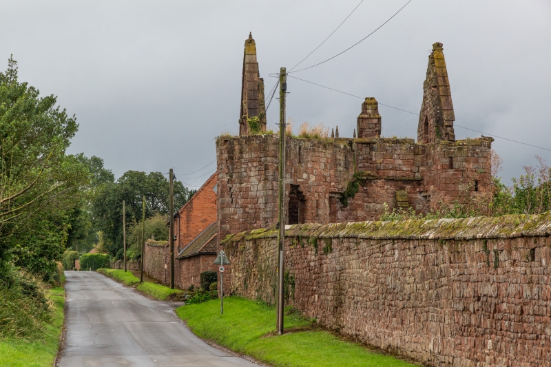
Outer gatehouse to former priory of Augustinian Canons. Early C14. Squared and irregularly coursed sandstone. Gables of original roof remain, but the rafters have been removed. Square plan.
Two storeys. Outer wall has at first floor a window of two-lights in two-centred chamfered arch, with fragments of reticulated tracery. On either side of this window are two C15 niches with trefoil cusping to canopies flanked by engaged shafts. Three-centred carriageway arch of two chamfered arches to each face. Inner arch is similar and has a similar window above. South west angle has octagonal stair vice, C15/C16, in ogee headed arch. North-west angle has a small projecting wing of three storeys. Adjoining precinct walls of similar squared and irregularly coursed sandstone with gable coping. At the east end, part of the precinct wall is incorporated in the north side wall of a C19 barn. Red brick with plain-tiled roof.
Interior: gatehouse has original cross wall with three-centred double chamfered arch to carriageway and on the west, a two-centred chamfered arch for pedestrians. Diagonal and ridge ribs to vaulting to three bays. Doorways have C19 plank doors but early C14 reset iron furniture.
Founded 1336 by William de Clinton, Earl of Huntingdon. Scheduled monument.
Listing NGR: SP2345286891
External links are from the relevant listing authority and, where applicable, Wikidata. Wikidata IDs may be related buildings as well as this specific building. If you want to add or update a link, you will need to do so by editing the Wikidata entry.


Other nearby listed buildings
