Approximate Location Map
Large Map »
Latitude: 52.4902 / 52°29'24"N
Longitude: -1.6596 / 1°39'34"W
OS Eastings: 423212
OS Northings: 288089
OS Grid: SP232880
Mapcode National: GBR 5JJ.TGN
Mapcode Global: VHBWH.6N0V
Plus Code: 9C4WF8RR+35
Entry Name: Barn 10 Metres West of Maxstoke School Farmhouse and Cattle Byre Adjoining on South West
Listing Date: 23 March 1988
Grade: II
Source: Historic England
Source ID: 1320319
English Heritage Legacy ID: 309029
ID on this website: 101320319
Location: North Warwickshire, B46
County: Warwickshire
District: North Warwickshire
Civil Parish: Maxstoke
Traditional County: Warwickshire
Lieutenancy Area (Ceremonial County): Warwickshire
Church of England Parish: Maxstoke
Church of England Diocese: Birmingham
Tagged with: Barn
MAXSTOKE FILLONGLEY ROAD
SP28NW (South side)
5/124 Barn 10m W of Maxstoke School
Farmhouse and cattle byre
adjoining on SW
GV II
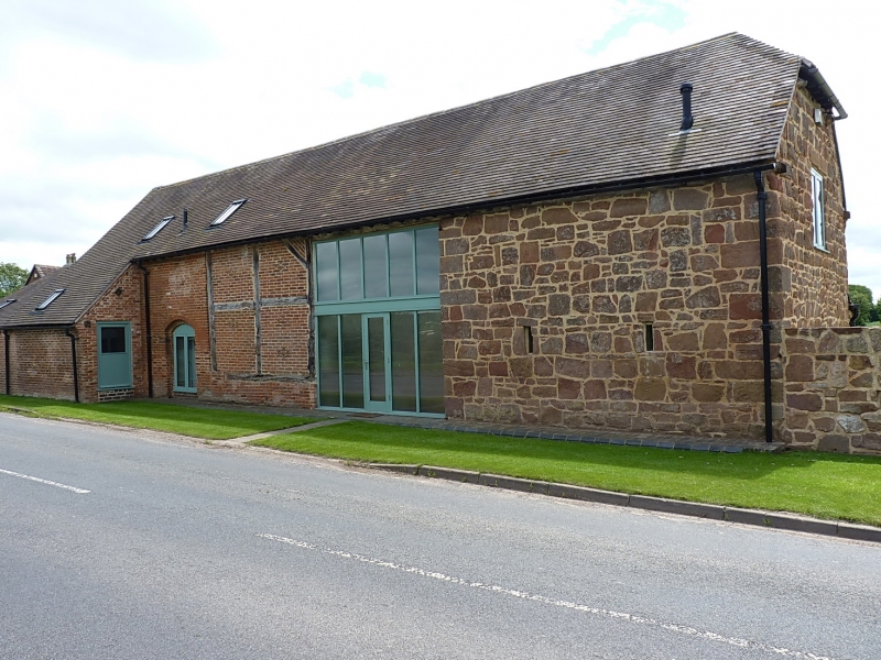
Barn. Early C17, late C17. C19. Timber-framed, coursed sandstone rubble, red
brick. Plain-tiled roof. Timber-framed bays of height of 2 panels to the north
wall. Wagon entry adjoining on the west and the westernmost part of the barn is
coursed sandstone rubble. There is dressed sandstone to the jamb of the wagon
entry on the west side. At the east end the wall is red brick,C19, but the
easternmost wall has been reduced in height to single storey. Adjoining cattle
byre on south-west. Sandstone rubble and plain-tiled roof.
Listing NGR: SP2321288089
External links are from the relevant listing authority and, where applicable, Wikidata. Wikidata IDs may be related buildings as well as this specific building. If you want to add or update a link, you will need to do so by editing the Wikidata entry.


Other nearby listed buildings
