Approximate Location Map
Large Map »
Latitude: 51.4209 / 51°25'15"N
Longitude: -1.7264 / 1°43'34"W
OS Eastings: 419122
OS Northings: 169135
OS Grid: SU191691
Mapcode National: GBR 4X2.VRP
Mapcode Global: VHC1P.1K52
Plus Code: 9C3WC7CF+9C
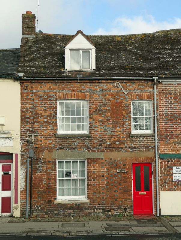
Entry Name: 9, London Road
Listing Date: 21 October 1974
Grade: II
Source: Historic England
Source ID: 1034205
English Heritage Legacy ID: 310424
ID on this website: 101034205
Location: Marlborough, Wiltshire, SN8
County: Wiltshire
Civil Parish: Marlborough
Built-Up Area: Marlborough
Traditional County: Wiltshire
Lieutenancy Area (Ceremonial County): Wiltshire
Tagged with: Building
LONDON ROAD
1.
5407
(East Side)
No 9
SU 1969 1/224
II GV
2.
C18. Chequer brick. Pitched old tile roof. 2 storeys and attic, Brick oversailing
course and zig-zag cornice at eaves. 2 ranges of sashes with glazing bars in reveals.
1 modern glazed door. 1 modern attic dormer.
Nos 9 to 12 (consec) The Five Alls public house, stables and coach house and
Nos 14 to 23 (consec) form a group.
Listing NGR: SU1912269135
External links are from the relevant listing authority and, where applicable, Wikidata. Wikidata IDs may be related buildings as well as this specific building. If you want to add or update a link, you will need to do so by editing the Wikidata entry.


Other nearby listed buildings
