Approximate Location Map
Large Map »
Latitude: 51.4207 / 51°25'14"N
Longitude: -1.7272 / 1°43'38"W
OS Eastings: 419062
OS Northings: 169113
OS Grid: SU190691
Mapcode National: GBR 4X2.VJ0
Mapcode Global: VHC1P.0KQ7
Plus Code: 9C3WC7CF+74
Entry Name: St Peter's and St Mary's Junior School
Listing Date: 21 October 1974
Grade: II
Source: Historic England
Source ID: 1258855
English Heritage Legacy ID: 310443
ID on this website: 101258855
Location: Marlborough, Wiltshire, SN8
County: Wiltshire
Civil Parish: Marlborough
Built-Up Area: Marlborough
Traditional County: Wiltshire
Lieutenancy Area (Ceremonial County): Wiltshire
Tagged with: School building
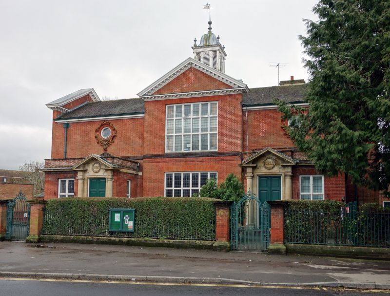
LONDON ROAD
1.
5407
(West Side)
St Peter's and St Mary's
Junior School
SU 1968 1/242
II
2.
1904 (date of foundation stone laid by the Marquess of Ailesbury). Architects
T B Silcock and S S Reay. Red brick. Pitched tile roof. 2 storeys. Moulded
wooden eaves cornice. End gables and (slightly projecting) central bay are crowned
by prominemt modillioned pediments. Centre bay has 1 range of mullioned and
transomed windows with lead glazing bars. 2 flanking bays have 1 oeuil de boeuf each
set in very elegant moulded brick cartouches. Below these are 1 storey entrance
extensions, each with moulded stone cornices and parapets: 1 double door each, with
fielded panelling in ashlar surrounds consisting of moulded architrave 2 Roman
Doric 3/4 columns taking full entablature and pediment with "Boys" and "Girls"
respectively carved in relief and wreathed by oak leafs: 1 mullion and transom window
in each extension, with lead glazing bars. Roof surmounted by octagonal lantern
on square tile-hung base, each side with semi-circular louvred arch with keystone
and moulded voussoirs. 4 Tuscan columns at corners taking entablature with
modillioned cornics, 4 elaborate wooden urns and ogival lead cap.
Listing NGR: SU1906269113
External links are from the relevant listing authority and, where applicable, Wikidata. Wikidata IDs may be related buildings as well as this specific building. If you want to add or update a link, you will need to do so by editing the Wikidata entry.


Other nearby listed buildings
